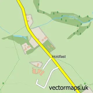
This Hanley Castle street map is a detailed vector street map covering a 750m x 750m area. Select a larger area to create and download your own vector street map of Hanley Castle.
The 750-metre map sample for Hanley Castle covers 105 mapped buildings and approximately 24.5 km of road detail, of which 3 named roads are named. The immediate area includes 1 school, 1 GP surgery within 2 miles, 1 pub and 4 MOT stations within 2 miles. The wider area around Hanley Castle features 1 food and drink venue and 1 campsite within 2 miles. To create a larger or custom map of Hanley Castle, the map builder lets you define your own coverage area and download editable SVG, PDF and PNG files.
Create a larger editable map of Hanley Castle
Choose any area you need and generate a high-quality vector map instantly. Perfect for print, planning, design, business and personal use.

This Hanley Castle street map in Worcestershire is available as downloadable SVG, PDF and PNG map files, or as a printed map for planning, business, display, education, local information and design work. You can also create a larger custom map area using the map selector.
What this Hanley Castle map sample shows
Hanley Castle lies within Hanley Castle Cp parish, part of Upton And Hanley ward in the Malvern Hills District local authority area. The postcode geography for this area includes the WR postcode area, the WR8 postcode district and the WR8 0 postcode sector. Residents fall under the Nhs Herefordshire And Worcestershire Integrated Care Board for NHS services.
Local features near Hanley Castle
Within 2 milesAmenities and services in and around Hanley Castle.
Administrative and postcode information for Hanley Castle
The local authority covering Hanley Castle is Malvern Hills District, within the county of Worcestershire. The settlement lies within Upton And Hanley ward and Hanley Castle Cp civil parish. The WR8 postcode district and WR8 0 postcode sector serve the immediate area. NHS provision in the area is delivered through Worcestershire Acute Hospitals Nhs Trust.
Nearby street map samples around Hanley Castle

More street maps in Worcestershire
750 metre map area coverage
Boundary, postcode and point of interest information for the 750m x 750m rectangle centred on this sample map.
Boundaries containing map centre
Constituency: West Worcestershire Co Const
County: Worcestershire County
District: Malvern Hills District
Icb: NHS Herefordshire and Worcestershire ICB
Parish: Hanley Castle CP
Police Force: west mercia
Postcode District: WR8
Postcode Sector: WR8 0
Ward: Powick & the Hanleys Ward
Nearby boundaries intersecting sample
No additional intersecting boundaries found.
Postcode coverage
POI category counts
High School: 2
Anglican Church: 1
Business Management Services: 1
Church Cathedral: 1
Environmental Conservation Organization: 1
Equestrian Facility: 1
Nursery And Gardening: 1
Online Shop: 1
Post Office: 1
Pub: 1
Sample points of interest
- St Mary
- The Business Partnership
- St Mary's Church
- British Flora
- Castlerhydd Equestrian
- Hanley Castle High School
- Hanley Castle High School
- Phoenix Amenity Supplies
- British Flora
- Hanley Castle Post Office
- Three Kings Inn
- Hanley Castle Sixth Form
Create a larger editable map of Hanley Castle
This sample shows only a 750 metre area. To create a larger map of Hanley Castle, use our map builder to choose your own coverage area, add titles and download editable SVG, PDF and PNG files.
Create a custom map of Hanley Castle