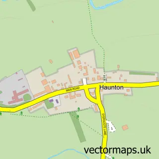
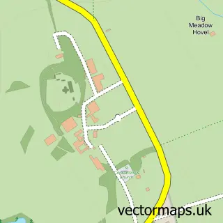
This Harlaston street map is a detailed vector street map covering a 750m x 750m area. Select a larger area to create and download your own vector street map of Harlaston.
The 750-metre map sample for Harlaston covers 122 mapped buildings and approximately 13.6 km of road detail, of which 5 named roads are named. The immediate area includes 1 pub. The wider area around Harlaston features 1 food and drink venue and 1 campsite within 2 miles. To create a larger or custom map of Harlaston, the map builder lets you define your own coverage area and download editable SVG, PDF and PNG files.
Create a larger editable map of Harlaston
Choose any area you need and generate a high-quality vector map instantly. Perfect for print, planning, design, business and personal use.

This Harlaston street map in Staffordshire is available as downloadable SVG, PDF and PNG map files, or as a printed map for planning, business, display, education, local information and design work. You can also create a larger custom map area using the map selector.
What this Harlaston map sample shows
Harlaston lies within Harlaston Cp parish, part of Mease Valley ward in the Lichfield District local authority area. The postcode geography for this area includes the B postcode area, the B79 postcode district and the B79 9 postcode sector. Residents fall under the Nhs Staffordshire And Stoke-On-Trent Integrated Care Board for NHS services.
Local features near Harlaston
Within 2 milesAmenities and services in and around Harlaston.
Administrative and postcode information for Harlaston
Harlaston lies within Harlaston Cp parish, part of Mease Valley ward in the Lichfield District local authority area. The postcode geography for this area includes the B postcode area, the B79 postcode district and the B79 9 postcode sector. Residents fall under the Nhs Staffordshire And Stoke-On-Trent Integrated Care Board for NHS services.
Nearby street map samples around Harlaston


More street maps in Staffordshire
750 metre map area coverage
Boundary, postcode and point of interest information for the 750m x 750m rectangle centred on this sample map.
Boundaries containing map centre
Constituency: Tamworth Co Const
County: Staffordshire County
District: Lichfield District
Icb: NHS Black Country ICB
Parish: Harlaston CP
Police Force: staffordshire
Postcode District: B79
Postcode Sector: B79 9
Ward: Mease Valley Ward
Nearby boundaries intersecting sample
Parish: Edingale CP
Postcode coverage
POI category counts
Anglican Church: 1
Bed And Breakfast: 1
Building Supply Store: 1
Community Center: 1
Event Planning: 1
Gym: 1
Linen: 1
Post Office: 1
Professional Services: 1
Pub: 1
Sample points of interest
- St Matthew's church Harlaston, Tamworth
- Harlaston Bed & Breakfast
- MHB Skip Hire
- Harlaston Village Hall
- Ashfield House Wedding and Event Venue
- Boogie Bounce Xtreme
- Mary Grice Soft Furnishings
- Harlaston Sub Post Office
- Unique Care Provider
- The White Lion
Create a larger editable map of Harlaston
This sample shows only a 750 metre area. To create a larger map of Harlaston, use our map builder to choose your own coverage area, add titles and download editable SVG, PDF and PNG files.
Create a custom map of Harlaston