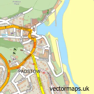
This Harlyn street map is a detailed vector street map covering a 750m x 750m area. Select a larger area to create and download your own vector street map of Harlyn.
The 750-metre map sample for Harlyn covers 84 mapped buildings and approximately 5.3 km of road detail, of which 1 named road are named. The immediate area includes 2 MOT stations within 2 miles. The wider area around Harlyn features 5 hotels and 5 campsites within 2 miles. To create a larger or custom map of Harlyn, the map builder lets you define your own coverage area and download editable SVG, PDF and PNG files.
Create a larger editable map of Harlyn
Choose any area you need and generate a high-quality vector map instantly. Perfect for print, planning, design, business and personal use.

This Harlyn street map in Cornwall is available as downloadable SVG, PDF and PNG map files, or as a printed map for planning, business, display, education, local information and design work. You can also create a larger custom map area using the map selector.
What this Harlyn map sample shows
Harlyn lies within St. Merryn Cp parish, part of Padstow ward in the Cornwall local authority area. The postcode geography for this area includes the PL postcode area, the PL28 postcode district and the PL28 8 postcode sector. Residents fall under the Nhs Cornwall And The Isles Of Scilly Integrated Care Board for NHS services.
Local features near Harlyn
Within 2 milesAmenities and services in and around Harlyn.
Administrative and postcode information for Harlyn
Harlyn lies within St. Merryn Cp parish, part of Padstow ward in the Cornwall local authority area. The postcode geography for this area includes the PL postcode area, the PL28 postcode district and the PL28 8 postcode sector. Residents fall under the Nhs Cornwall And The Isles Of Scilly Integrated Care Board for NHS services.
Nearby street map samples around Harlyn


More street maps in Cornwall
750 metre map area coverage
Boundary, postcode and point of interest information for the 750m x 750m rectangle centred on this sample map.
Boundaries containing map centre
Constituency: North Cornwall Co Const
District: Cornwall
Icb: NHS Cornwall and the Isles of Scilly ICB
Parish: St. Merryn CP
Police Force: devon and cornwall
Postcode District: PL28
Postcode Sector: PL28 8
Nearby boundaries intersecting sample
Parish: Padstow CP
Postcode coverage
POI category counts
Hotel: 5
Pet Boarding: 3
Accommodation: 1
Active Life: 1
Architect: 1
Beach: 1
Cottage: 1
Holiday Rental Home: 1
Parking: 1
Sandwich Shop: 1
Sample points of interest
- The Mews
- Harlyn Surf School
- Caullystone
- Harlyn Beach
- Yellow Sands Cottages
- Yellow Sands Apartments & House
- Mermaid’s Rest 8 Harlyn Mews - Nr Padstow - Self Cater Cottage
- Polmark Beach Cottages
- Self Catering Apartments And House at Yellow Sands
- Sharmalyn House Yellow Sands
- Yellow Sands Self Catering Apartments
- Harlyn Bridge
Create a larger editable map of Harlyn
This sample shows only a 750 metre area. To create a larger map of Harlyn, use our map builder to choose your own coverage area, add titles and download editable SVG, PDF and PNG files.
Create a custom map of Harlyn