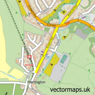
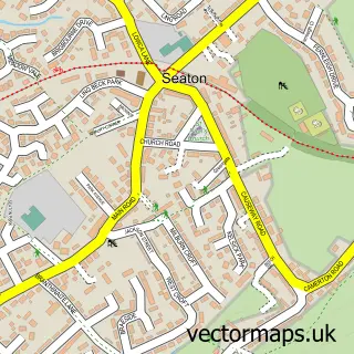
This High Harrington street map is a detailed vector street map covering a 750m x 750m area. Select a larger area to create and download your own vector street map of High Harrington.
The 750-metre map sample for High Harrington covers 393 mapped buildings and approximately 10.1 km of road detail, of which 18 named roads are named. The immediate area includes 1 GP surgery within 2 miles, 1 pub and 16 MOT stations within 2 miles. The wider area around High Harrington features 1 tourism point of interest and 1 food and drink venue. To create a larger or custom map of High Harrington, the map builder lets you define your own coverage area and download editable SVG, PDF and PNG files.
Create a larger editable map of High Harrington
Choose any area you need and generate a high-quality vector map instantly. Perfect for print, planning, design, business and personal use.

This High Harrington street map in Cumbria is available as downloadable SVG, PDF and PNG map files, or as a printed map for planning, business, display, education, local information and design work. You can also create a larger custom map area using the map selector.
What this High Harrington map sample shows
High Harrington lies within Workington Cp parish, part of Harrington & Salterbeck ward in the Cumberland local authority area. The postcode geography for this area includes the CA postcode area, the CA14 postcode district and the CA14 4 postcode sector. Residents fall under the Nhs North East And North Cumbria Integrated Care Board for NHS services.
Local features near High Harrington
Within 2 milesAmenities and services in and around High Harrington.
Administrative and postcode information for High Harrington
The local authority covering High Harrington is Cumberland, within the county of Cumbria. The settlement lies within Harrington & Salterbeck ward and Workington Cp civil parish. The CA14 postcode district and CA14 4 postcode sector serve the immediate area. NHS provision in the area is delivered through North Cumbria Integrated Care Nhs Foundation Trust.
Nearby street map samples around High Harrington

More street maps in Cumbria
750 metre map area coverage
Boundary, postcode and point of interest information for the 750m x 750m rectangle centred on this sample map.
Boundaries containing map centre
Constituency: Whitehaven and Workington Co Const
District: Cumberland
Icb: NHS North East and North Cumbria ICB
Parish: Workington CP
Police Force: cumbria
Postcode District: CA14
Postcode Sector: CA14 4
Ward: Harrington Ward
Nearby boundaries intersecting sample
Postcode Sector: CA14 5
Postcode coverage
POI category counts
Assisted Living Facility: 1
Bridal Shop: 1
Convenience Store: 1
Hat Shop: 1
Home Developer: 1
Landmark And Historical Building: 1
Laundry Services: 1
Pub: 1
Retail: 1
Retirement Home: 1
Sample points of interest
- Brancaster Care Homes
- Karen Jones Photography
- One Stop
- SB Millinery
- Whins View - Story Homes, Workington
- High Harrington
- A2K Cleaning Services Limited
- Galloping Horse
- Ian Wilson Haulage
- East Croft Grange
- Post Office-Seaton
- High Harrington railway station
Create a larger editable map of High Harrington
This sample shows only a 750 metre area. To create a larger map of High Harrington, use our map builder to choose your own coverage area, add titles and download editable SVG, PDF and PNG files.
Create a custom map of High Harrington