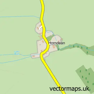
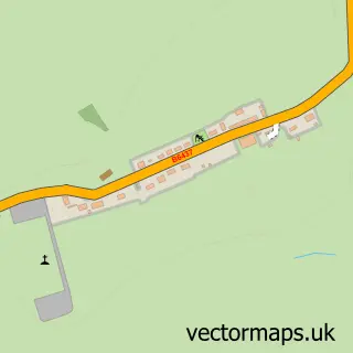
This Horncliffe street map is a detailed vector street map covering a 750m x 750m area. Select a larger area to create and download your own vector street map of Horncliffe.
The 750-metre map sample for Horncliffe covers 119 mapped buildings and approximately 5.9 km of road detail, of which 7 named roads are named. The immediate area includes 2 pubs. The wider area around Horncliffe features 2 food and drink venues and 1 hotel. To create a larger or custom map of Horncliffe, the map builder lets you define your own coverage area and download editable SVG, PDF and PNG files.
Create a larger editable map of Horncliffe
Choose any area you need and generate a high-quality vector map instantly. Perfect for print, planning, design, business and personal use.

This Horncliffe street map in Northumberland is available as downloadable SVG, PDF and PNG map files, or as a printed map for planning, business, display, education, local information and design work. You can also create a larger custom map area using the map selector.
What this Horncliffe map sample shows
Horncliffe lies within Horncliffe Cp parish, part of Norham And Islandshires ward in the Northumberland local authority area. The postcode geography for this area includes the TD postcode area, the TD15 postcode district and the TD15 2 postcode sector. Residents fall under the Nhs North East And North Cumbria Integrated Care Board for NHS services.
Local features near Horncliffe
Within 2 milesAmenities and services in and around Horncliffe.
Administrative and postcode information for Horncliffe
The local authority covering Horncliffe is Northumberland, within the county of Northumberland. The settlement lies within Norham And Islandshires ward and Horncliffe Cp civil parish. The TD15 postcode district and TD15 2 postcode sector serve the immediate area. NHS provision in the area is delivered through Northumbria Healthcare Nhs Foundation Trust.
Nearby street map samples around Horncliffe

More street maps in Northumberland
750 metre map area coverage
Boundary, postcode and point of interest information for the 750m x 750m rectangle centred on this sample map.
Boundaries containing map centre
Constituency: North Northumberland Co Const
District: Northumberland
Icb: NHS North East and North Cumbria ICB
Parish: Horncliffe CP
Police Force: northumberland
Postcode District: TD15
Postcode Sector: TD15 2
Nearby boundaries intersecting sample
Constituency: Berwickshire, Roxburgh and Selkirk Co Const
District: Scottish Borders
Icb: Borders
Parish: Norham CP
Postcode Sector: TD15 1
Ward: East Berwickshire Ward
Postcode coverage
POI category counts
Pub: 2
Active Life: 1
Bed And Breakfast: 1
Driving School: 1
Event Photography: 1
Hotel: 1
Public Service And Government: 1
Veterinarian: 1
Sample points of interest
- Active 4 Seasons
- The Old Church
- Barry Youngman School of Motoring
- Sky Vantage Productions - Filming and Photography
- Whitecroft Holiday Cottage
- Fishers Arms Horncliffe Community Benefit Society
- Fishers Arms Pub
- Horncliffe Village Hall
- Medivet
Create a larger editable map of Horncliffe
This sample shows only a 750 metre area. To create a larger map of Horncliffe, use our map builder to choose your own coverage area, add titles and download editable SVG, PDF and PNG files.
Create a custom map of Horncliffe