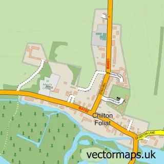
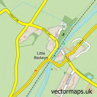
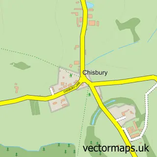
This Hungerford street map is a detailed vector street map covering a 750m x 750m area. Select a larger area to create and download your own vector street map of Hungerford.
The 750-metre map sample for Hungerford covers 381 mapped buildings and approximately 15.9 km of road detail, of which 33 named roads are named. The immediate area includes 1 school, 1 railway station, 1 GP surgery and 7 pubs among other local services. The wider area around Hungerford features 4 tourism points of interest, 13 food and drink venues and 4 hotels. To create a larger or custom map of Hungerford, the map builder lets you define your own coverage area and download editable SVG, PDF and PNG files.
Create a larger editable map of Hungerford
Choose any area you need and generate a high-quality vector map instantly. Perfect for print, planning, design, business and personal use.

This Hungerford street map in Berkshire is available as downloadable SVG, PDF and PNG map files, or as a printed map for planning, business, display, education, local information and design work. You can also create a larger custom map area using the map selector.
What this Hungerford map sample shows
Hungerford lies within Hungerford Cp parish, part of Hungerford & Kintbury ward in the West Berkshire local authority area. The postcode geography for this area includes the RG postcode area, the RG17 postcode district and the RG17 0 postcode sector. Residents fall under the Nhs Buckinghamshire, Oxfordshire And Berkshire West Integrated Care Board for NHS services.
Local features near Hungerford
Within 2 milesAmenities and services in and around Hungerford.
Administrative and postcode information for Hungerford
The local authority covering Hungerford is West Berkshire, within the county of Berkshire. The settlement lies within Hungerford & Kintbury ward and Hungerford Cp civil parish. The RG17 postcode district and RG17 0 postcode sector serve the immediate area. NHS provision in the area is delivered through Great Western Hospitals Nhs Foundation Trust.
Nearby street map samples around Hungerford

More street maps in Berkshire
750 metre map area coverage
Boundary, postcode and point of interest information for the 750m x 750m rectangle centred on this sample map.
Boundaries containing map centre
Constituency: Newbury Co Const
District: West Berkshire
Icb: NHS Thames Valley ICB
Parish: Hungerford CP
Police Force: thames valley
Postcode District: RG17
Postcode Sector: RG17 0
Ward: Hungerford & Kintbury Ward
Nearby boundaries intersecting sample
No additional intersecting boundaries found.
Postcode coverage
POI category counts
Antique Store: 18
Hair Salon: 10
Flowers And Gifts Shop: 7
Pub: 7
Clothing Store: 6
Jewelry Store: 6
Real Estate Agent: 6
Beauty Salon: 5
Professional Services: 5
Accountant: 4
Sample points of interest
- Hungerford Accountants - RiverView Portfolio
- L J Smith Accountants Ltd
- LJ Smith Accountants Ltd.
- Sunforce Services Pvt Ltd t/a Isaac Accountancy
- Kennet And Avon Canal Hungerford
- Clearthinking Creative
- Three Marketeers
- Alyce Holst
- D R Hamm
- Frobury Farm
- St Lawrence's, Hungerford
- Beedham Antiques
Create a larger editable map of Hungerford
This sample shows only a 750 metre area. To create a larger map of Hungerford, use our map builder to choose your own coverage area, add titles and download editable SVG, PDF and PNG files.
Create a custom map of Hungerford