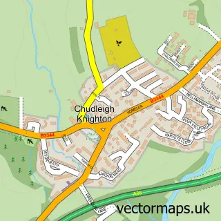
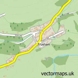
This Ideford street map is a detailed vector street map covering a 750m x 750m area. Select a larger area to create and download your own vector street map of Ideford.
The 750-metre map sample for Ideford covers 119 mapped buildings and approximately 7.2 km of road detail, of which 9 named roads are named. The immediate area includes 2 pubs and 1 MOT station. The wider area around Ideford features 1 tourism point of interest and 2 food and drink venues. To create a larger or custom map of Ideford, the map builder lets you define your own coverage area and download editable SVG, PDF and PNG files.
Create a larger editable map of Ideford
Choose any area you need and generate a high-quality vector map instantly. Perfect for print, planning, design, business and personal use.

This Ideford street map in Devon is available as downloadable SVG, PDF and PNG map files, or as a printed map for planning, business, display, education, local information and design work. You can also create a larger custom map area using the map selector.
What this Ideford map sample shows
Ideford lies within Ideford Cp parish, part of Kingsteignton East ward in the Teignbridge District local authority area. The postcode geography for this area includes the TQ postcode area, the TQ13 postcode district and the TQ13 0 postcode sector. Residents fall under the Nhs Devon Integrated Care Board for NHS services.
Local features near Ideford
Within 2 milesAmenities and services in and around Ideford.
Administrative and postcode information for Ideford
The local authority covering Ideford is Teignbridge District, within the county of Devon. The settlement lies within Kingsteignton East ward and Ideford Cp civil parish. The TQ13 postcode district and TQ13 0 postcode sector serve the immediate area. NHS provision in the area is delivered through Torbay And South Devon Nhs Foundation Trust.
Nearby street map samples around Ideford

More street maps in Devon
750 metre map area coverage
Boundary, postcode and point of interest information for the 750m x 750m rectangle centred on this sample map.
Boundaries containing map centre
Constituency: Newton Abbot Co Const
County: Devon County
District: Teignbridge District
Icb: NHS Devon ICB
Parish: Ideford CP
Police Force: devon and cornwall
Postcode District: TQ13
Postcode Sector: TQ13 0
Ward: Kingsteignton East Ward
Nearby boundaries intersecting sample
No additional intersecting boundaries found.
Postcode coverage
POI category counts
Pub: 2
Anglican Church: 1
Building Supply Store: 1
Home Service: 1
Horse Boarding: 1
Media Agency: 1
Metal Fabricator: 1
Park: 1
Pet Store: 1
Swimming Instructor: 1
Sample points of interest
- St Mary's, Ideford
- Traditional Building & Conservation Co.Ltd
- James French Carpenter
- Hestow Stables
- Biograph
- Paul Rice Fabrications
- Ideford Millennium Green
- Healthy Hounds Newton Abbot
- Royal Oak Inn
- The Royal Oak Inn
- Forever Swimming Swim School
- Ideford Village Hall
Create a larger editable map of Ideford
This sample shows only a 750 metre area. To create a larger map of Ideford, use our map builder to choose your own coverage area, add titles and download editable SVG, PDF and PNG files.
Create a custom map of Ideford