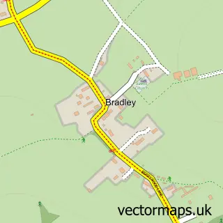
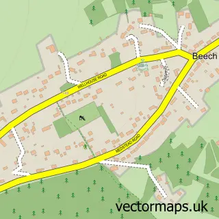
This Lasham street map is a detailed vector street map covering a 750m x 750m area. Select a larger area to create and download your own vector street map of Lasham.
The 750-metre map sample for Lasham covers 82 mapped buildings and approximately 13.0 km of road detail. The immediate area includes 1 pub. The wider area around Lasham features 1 food and drink venue. To create a larger or custom map of Lasham, the map builder lets you define your own coverage area and download editable SVG, PDF and PNG files.
Create a larger editable map of Lasham
Choose any area you need and generate a high-quality vector map instantly. Perfect for print, planning, design, business and personal use.

This Lasham street map in Hampshire is available as downloadable SVG, PDF and PNG map files, or as a printed map for planning, business, display, education, local information and design work. You can also create a larger custom map area using the map selector.
What this Lasham map sample shows
Lasham lies within Lasham Cp parish, part of Bentworth & Froyle ward in the East Hampshire District local authority area. The postcode geography for this area includes the GU postcode area, the GU34 postcode district and the GU34 5 postcode sector. Residents fall under the Nhs Hampshire And Isle Of Wight Integrated Care Board for NHS services.
Local features near Lasham
Within 2 milesAmenities and services in and around Lasham.
Administrative and postcode information for Lasham
Lasham lies within Lasham Cp parish, part of Bentworth & Froyle ward in the East Hampshire District local authority area. The postcode geography for this area includes the GU postcode area, the GU34 postcode district and the GU34 5 postcode sector. Residents fall under the Nhs Hampshire And Isle Of Wight Integrated Care Board for NHS services.
Nearby street map samples around Lasham


More street maps in Hampshire
750 metre map area coverage
Boundary, postcode and point of interest information for the 750m x 750m rectangle centred on this sample map.
Boundaries containing map centre
Constituency: East Hampshire Co Const
County: Hampshire County
District: East Hampshire District
Icb: NHS Hampshire and Isle of Wight ICB
Parish: Lasham CP
Police Force: hampshire
Postcode District: GU34
Postcode Sector: GU34 5
Ward: Bentworth & Froyle Ward
Nearby boundaries intersecting sample
No additional intersecting boundaries found.
Postcode coverage
POI category counts
Anglican Church: 1
Arts And Entertainment: 1
Broadcasting Media Production: 1
Building Supply Store: 1
Business Consulting: 1
Business Management Services: 1
Corporate Entertainment Services: 1
Estate Planning Law: 1
Home Cleaning: 1
Metal Fabricator: 1
Sample points of interest
- St Mary's Church, Lasham
- The Bronze Art Workshop
- MoviehouseEntertainment
- Hugo Egleston Furniture
- 381 Consultancy
- 381 Consultancy Ltd.
- Skirmish Paintball Games
- Aps Legal & Associates
- Iconic Window Cleaning
- The Bronze Art Workshop
- Invisable Freedom Fence
- Stand 4 Ltd.
Create a larger editable map of Lasham
This sample shows only a 750 metre area. To create a larger map of Lasham, use our map builder to choose your own coverage area, add titles and download editable SVG, PDF and PNG files.
Create a custom map of Lasham