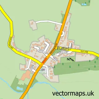
This Lavister street map is a detailed vector street map covering a 750m x 750m area. Select a larger area to create and download your own vector street map of Lavister.
The 750-metre map sample for Lavister covers 112 mapped buildings and approximately 7.4 km of road detail, of which 11 named roads are named. The immediate area includes 1 GP surgery within 2 miles and 2 pubs. The wider area around Lavister features 2 food and drink venues. To create a larger or custom map of Lavister, the map builder lets you define your own coverage area and download editable SVG, PDF and PNG files.
Create a larger editable map of Lavister
Choose any area you need and generate a high-quality vector map instantly. Perfect for print, planning, design, business and personal use.

This Lavister street map in Clwyd is available as downloadable SVG, PDF and PNG map files, or as a printed map for planning, business, display, education, local information and design work. You can also create a larger custom map area using the map selector.
What this Lavister map sample shows
Lavister lies within Poulton And Pulford Cp parish, part of Christleton & Huntington ward in the Cheshire West And Chester (B) local authority area. The postcode geography for this area includes the CH postcode area, the CH4 postcode district and the CH4 9 postcode sector. Residents fall under the Nhs Cheshire And Merseyside Integrated Care Board for NHS services.
Local features near Lavister
Within 2 milesAmenities and services in and around Lavister.
Administrative and postcode information for Lavister
Lavister lies within Poulton And Pulford Cp parish, part of Christleton & Huntington ward in the Cheshire West And Chester (B) local authority area. The postcode geography for this area includes the CH postcode area, the CH4 postcode district and the CH4 9 postcode sector. Residents fall under the Nhs Cheshire And Merseyside Integrated Care Board for NHS services.
Nearby street map samples around Lavister


More street maps in Clwyd
750 metre map area coverage
Boundary, postcode and point of interest information for the 750m x 750m rectangle centred on this sample map.
Boundaries containing map centre
Constituency: Wrexham Co Const
District: Wrecsam - Wrexham
Icb: Betsi Cadwaladr University
Parish: Rossett Community
Police Force: north wales
Postcode District: LL12
Postcode Sector: LL12 0
Nearby boundaries intersecting sample
Constituency: Chester South and Eddisbury Co Const
District: Cheshire West and Chester (B)
Icb: NHS Cheshire and Merseyside ICB
Parish: Poulton and Pulford CP
Police Force: cheshire
Postcode District: CH4
Postcode Sector: CH4 9
Ward: Christleton & Huntington Ward
Postcode coverage
POI category counts
Bridal Shop: 2
Driving School: 2
Professional Services: 2
Pub: 2
Veterinarian: 2
Active Life: 1
Advertising Agency: 1
Bakery: 1
Business Consulting: 1
Business Management Services: 1
Sample points of interest
- Darland Golf
- UK Advisers
- Sweet Street Bakery
- Country House Wedding Venues
- Selected Venues
- A Q R
- Clarendons
- Beebespoke
- LDC Driving School: Tom Bate
- Rossett Driving School
- Teach Active
- Diagnostic Solutions Ltd.
Create a larger editable map of Lavister
This sample shows only a 750 metre area. To create a larger map of Lavister, use our map builder to choose your own coverage area, add titles and download editable SVG, PDF and PNG files.
Create a custom map of Lavister