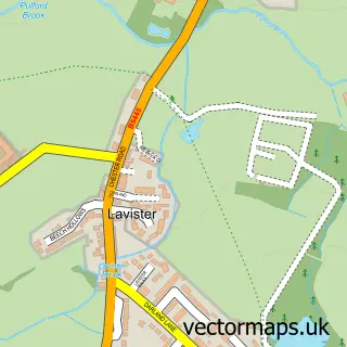
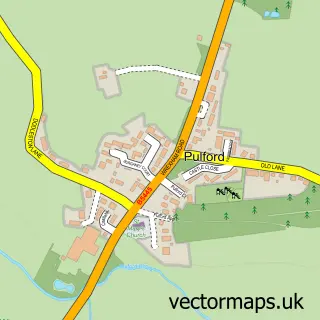
This Rossett street map is a detailed vector street map covering a 750m x 750m area. Select a larger area to create and download your own vector street map of Rossett.
The 750-metre map sample for Rossett covers 335 mapped buildings and approximately 14.1 km of road detail, of which 23 named roads are named. The immediate area includes 1 school, 1 GP surgery within 2 miles, 3 pubs and 1 MOT station within 2 miles. The wider area around Rossett features 7 food and drink venues and 1 hotel. To create a larger or custom map of Rossett, the map builder lets you define your own coverage area and download editable SVG, PDF and PNG files.
Create a larger editable map of Rossett
Choose any area you need and generate a high-quality vector map instantly. Perfect for print, planning, design, business and personal use.

This Rossett street map in Clwyd is available as downloadable SVG, PDF and PNG map files, or as a printed map for planning, business, display, education, local information and design work. You can also create a larger custom map area using the map selector.
What this Rossett map sample shows
Rossett lies within Rossett Community parish, part of Rossett ward in the Wrecsam - Wrexham local authority area. The postcode geography for this area includes the LL postcode area, the LL12 postcode district and the LL12 0 postcode sector. Residents fall under the Betsi Cadwaladr University Health Board for NHS services.
Local features near Rossett
Within 2 milesAmenities and services in and around Rossett.
Administrative and postcode information for Rossett
The local authority covering Rossett is Wrecsam - Wrexham, within the county of Clwyd. The settlement lies within Rossett ward and Rossett Community civil parish. The LL12 postcode district and LL12 0 postcode sector serve the immediate area. NHS provision in the area is delivered through Betsi Cadwaladr University Health Board.
Nearby street map samples around Rossett


More street maps in Clwyd
750 metre map area coverage
Boundary, postcode and point of interest information for the 750m x 750m rectangle centred on this sample map.
Boundaries containing map centre
Constituency: Wrexham Co Const
District: Wrecsam - Wrexham
Icb: Betsi Cadwaladr University
Parish: Rossett Community
Police Force: north wales
Postcode District: LL12
Postcode Sector: LL12 0
Nearby boundaries intersecting sample
No additional intersecting boundaries found.
Postcode coverage
POI category counts
Beauty Salon: 3
Pub: 3
Automotive Repair: 2
Community Services Non Profits: 2
Hair Salon: 2
Land Surveying: 2
Restaurant: 2
Accountant: 1
Agriculture: 1
Arts And Entertainment: 1
Sample points of interest
- R M D Accountancy Solutions Ltd.
- Rossett Park Farming
- Rossett
- The Cooperative Food Rossett Chester Rd, Rossett
- Newhaven Motor Co.
- A a Saab
- Remap Auto Tuning
- NatWest Mobile Branch
- Kim B Beauty
- Nat Cargius - Hairdresser & Cosmetic Hair Consultant
- Salon One 20 Rossett
- Field & Falcon
Create a larger editable map of Rossett
This sample shows only a 750 metre area. To create a larger map of Rossett, use our map builder to choose your own coverage area, add titles and download editable SVG, PDF and PNG files.
Create a custom map of Rossett