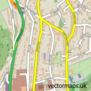
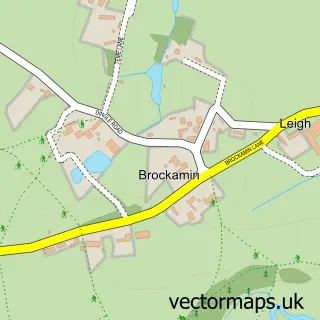
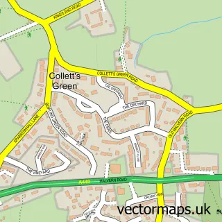
This Leigh Sinton street map is a detailed vector street map covering a 750m x 750m area. Select a larger area to create and download your own vector street map of Leigh Sinton.
The 750-metre map sample for Leigh Sinton covers 302 mapped buildings and approximately 35.3 km of road detail, of which 15 named roads are named. The immediate area includes 1 GP surgery within 2 miles, 2 pubs and 9 MOT stations within 2 miles. The wider area around Leigh Sinton features 3 food and drink venues. To create a larger or custom map of Leigh Sinton, the map builder lets you define your own coverage area and download editable SVG, PDF and PNG files.
Create a larger editable map of Leigh Sinton
Choose any area you need and generate a high-quality vector map instantly. Perfect for print, planning, design, business and personal use.

This Leigh Sinton street map in Worcestershire is available as downloadable SVG, PDF and PNG map files, or as a printed map for planning, business, display, education, local information and design work. You can also create a larger custom map area using the map selector.
What this Leigh Sinton map sample shows
Leigh Sinton lies within Leigh Cp parish, part of Alfrick And Leigh ward in the Malvern Hills District local authority area. The postcode geography for this area includes the WR postcode area, the WR13 postcode district and the WR13 5 postcode sector. Residents fall under the Nhs Herefordshire And Worcestershire Integrated Care Board for NHS services.
Local features near Leigh Sinton
Within 2 milesAmenities and services in and around Leigh Sinton.
Administrative and postcode information for Leigh Sinton
Leigh Sinton lies within Leigh Cp parish, part of Alfrick And Leigh ward in the Malvern Hills District local authority area. The postcode geography for this area includes the WR postcode area, the WR13 postcode district and the WR13 5 postcode sector. Residents fall under the Nhs Herefordshire And Worcestershire Integrated Care Board for NHS services.
Nearby street map samples around Leigh Sinton

More street maps in Worcestershire
750 metre map area coverage
Boundary, postcode and point of interest information for the 750m x 750m rectangle centred on this sample map.
Boundaries containing map centre
Constituency: West Worcestershire Co Const
County: Worcestershire County
District: Malvern Hills District
Icb: NHS Herefordshire and Worcestershire ICB
Parish: Leigh CP
Police Force: west mercia
Postcode District: WR13
Postcode Sector: WR13 5
Ward: Alfrick, Leigh & Rushwick Ward
Nearby boundaries intersecting sample
No additional intersecting boundaries found.
Postcode coverage
POI category counts
Beauty Salon: 2
Convenience Store: 2
Martial Arts Club: 2
Pub: 2
Retirement Home: 2
Tree Services: 2
Active Life: 1
Assisted Living Facility: 1
Auto Upholstery: 1
Beauty And Spa: 1
Sample points of interest
- AeroCombat
- Waterside Care Centre
- Clements Upholstery
- Metamorphose Beauty Salon Malvern
- Iona Organic Hair and Colour
- The Haven Hair Studio
- Woodman Joinery
- Branches Coffee Hatch
- Londis
- Premier Stores
- Tramps Nightclub
- Branches Day Opportunities Ltd.
Create a larger editable map of Leigh Sinton
This sample shows only a 750 metre area. To create a larger map of Leigh Sinton, use our map builder to choose your own coverage area, add titles and download editable SVG, PDF and PNG files.
Create a custom map of Leigh Sinton