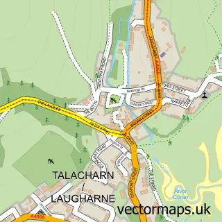
This Llansteffan street map is a detailed vector street map covering a 750m x 750m area. Select a larger area to create and download your own vector street map of Llansteffan.
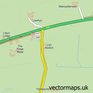
The 750-metre map sample for Llansteffan covers 175 mapped buildings and approximately 11.1 km of road detail, of which 9 named roads are named. The immediate area includes 1 school, 1 pub and 1 MOT station within 2 miles. The wider area around Llansteffan features 2 food and drink venues, 4 hotels and 1 campsite within 2 miles. To create a larger or custom map of Llansteffan, the map builder lets you define your own coverage area and download editable SVG, PDF and PNG files.
Create a larger editable map of Llansteffan
Choose any area you need and generate a high-quality vector map instantly. Perfect for print, planning, design, business and personal use.

This Llansteffan street map in Dyfed is available as downloadable SVG, PDF and PNG map files, or as a printed map for planning, business, display, education, local information and design work. You can also create a larger custom map area using the map selector.
What this Llansteffan map sample shows
Llansteffan lies within Llansteffan Community parish, part of Llansteffan ward in the Sir Gaerfyrddin - Carmarthenshire local authority area. The postcode geography for this area includes the SA postcode area, the SA33 postcode district and the SA33 5 postcode sector. Residents fall under the Hywel Dda University Health Board for NHS services.
Local features near Llansteffan
Within 2 milesAmenities and services in and around Llansteffan.
Administrative and postcode information for Llansteffan
Llansteffan lies within Llansteffan Community parish, part of Llansteffan ward in the Sir Gaerfyrddin - Carmarthenshire local authority area. The postcode geography for this area includes the SA postcode area, the SA33 postcode district and the SA33 5 postcode sector. Residents fall under the Hywel Dda University Health Board for NHS services.
Nearby street map samples around Llansteffan

More street maps in Dyfed
750 metre map area coverage
Boundary, postcode and point of interest information for the 750m x 750m rectangle centred on this sample map.
Boundaries containing map centre
Constituency: Caerfyrddin Co Const
District: Sir Gaerfyrddin - Carmarthenshire
Icb: Hywel Dda
Parish: Llansteffan Community
Police Force: dyfed-powys
Postcode District: SA33
Postcode Sector: SA33 5
Nearby boundaries intersecting sample
No additional intersecting boundaries found.
Postcode coverage
POI category counts
Holiday Rental Home: 3
Hotel: 3
Beach: 2
Kids Recreation And Party: 2
Post Office: 2
Accommodation: 1
Anglican Church: 1
Animation Studio: 1
Art Gallery: 1
Arts And Crafts: 1
Sample points of interest
- Sunrise Bay
- St Ystyffan's Church, Llansteffan
- Picmo Animation Studio
- Old Pound Gallery
- The Oystercatcher Gallery
- Bethany Baptist Church
- Llansteffan Beach
- Scotts Bay Llansteffan
- Village Stores
- WAINWRIGHTS
- The Sticks
- Make and Mend Workshop
Create a larger editable map of Llansteffan
This sample shows only a 750 metre area. To create a larger map of Llansteffan, use our map builder to choose your own coverage area, add titles and download editable SVG, PDF and PNG files.
Create a custom map of Llansteffan