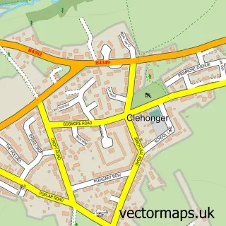
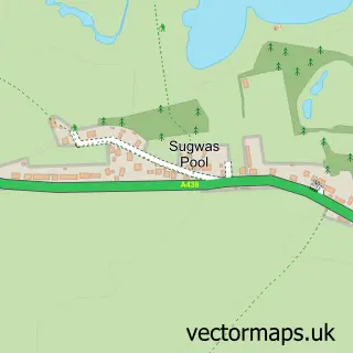
This Madley street map is a detailed vector street map covering a 750m x 750m area. Select a larger area to create and download your own vector street map of Madley.
The 750-metre map sample for Madley covers 248 mapped buildings and approximately 33.4 km of road detail, of which 10 named roads are named. The immediate area includes 1 school, 1 GP surgery within 2 miles, 1 pub and 1 MOT station within 2 miles. The wider area around Madley features 3 food and drink venues. To create a larger or custom map of Madley, the map builder lets you define your own coverage area and download editable SVG, PDF and PNG files.
Create a larger editable map of Madley
Choose any area you need and generate a high-quality vector map instantly. Perfect for print, planning, design, business and personal use.

This Madley street map in Herefordshire is available as downloadable SVG, PDF and PNG map files, or as a printed map for planning, business, display, education, local information and design work. You can also create a larger custom map area using the map selector.
What this Madley map sample shows
Madley lies within Madley Cp parish, part of Stoney Street ward in the County Of Herefordshire local authority area. The postcode geography for this area includes the HR postcode area, the HR2 postcode district and the HR2 9 postcode sector. Residents fall under the Nhs Herefordshire And Worcestershire Integrated Care Board for NHS services.
Local features near Madley
Within 2 milesAmenities and services in and around Madley.
Administrative and postcode information for Madley
The local authority covering Madley is County Of Herefordshire, within the county of Herefordshire. The settlement lies within Stoney Street ward and Madley Cp civil parish. The HR2 postcode district and HR2 9 postcode sector serve the immediate area. NHS provision in the area is delivered through Wye Valley Nhs Trust.
Nearby street map samples around Madley

More street maps in Herefordshire
750 metre map area coverage
Boundary, postcode and point of interest information for the 750m x 750m rectangle centred on this sample map.
Boundaries containing map centre
Constituency: Hereford and South Herefordshire Co Const
District: County of Herefordshire
Icb: NHS Herefordshire and Worcestershire ICB
Parish: Madley CP
Police Force: west mercia
Postcode District: HR2
Postcode Sector: HR2 9
Ward: Stoney Street Ward
Nearby boundaries intersecting sample
No additional intersecting boundaries found.
Postcode coverage
POI category counts
Restaurant: 2
Shipping Center: 2
Advertising Agency: 1
Anglican Church: 1
Business Consulting: 1
Church Cathedral: 1
Community Services Non Profits: 1
Convenience Store: 1
Elementary School: 1
Financial Service: 1
Sample points of interest
- Cayo Retreat
- Madley: Nativity of the Blessed Virgin Mary
- Stepping Stones Consultancy
- Madley Parish Church
- Madley Village Hall
- Londis
- Madley Primary School
- Beacon Associates UK
- MarKays Plaice 2 Plaice
- Kenosis
- Hereford Motorbike Services
- The Red Lion
Create a larger editable map of Madley
This sample shows only a 750 metre area. To create a larger map of Madley, use our map builder to choose your own coverage area, add titles and download editable SVG, PDF and PNG files.
Create a custom map of Madley