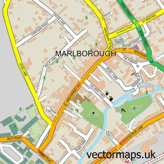
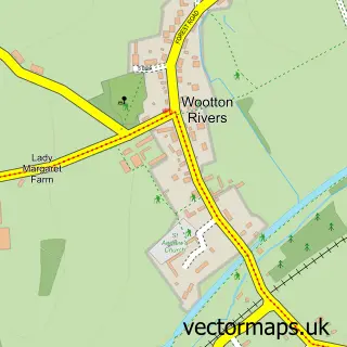
This Manton street map is a detailed vector street map covering a 750m x 750m area. Select a larger area to create and download your own vector street map of Manton.
The 750-metre map sample for Manton covers 213 mapped buildings and approximately 13.8 km of road detail, of which 15 named roads are named. The immediate area includes 1 school, 1 GP surgery within 2 miles, 2 pubs and 6 MOT stations within 2 miles. The wider area around Manton features 1 tourism point of interest, 2 food and drink venues and 1 campsite within 2 miles. To create a larger or custom map of Manton, the map builder lets you define your own coverage area and download editable SVG, PDF and PNG files.
Create a larger editable map of Manton
Choose any area you need and generate a high-quality vector map instantly. Perfect for print, planning, design, business and personal use.

This Manton street map in Wiltshire is available as downloadable SVG, PDF and PNG map files, or as a printed map for planning, business, display, education, local information and design work. You can also create a larger custom map area using the map selector.
What this Manton map sample shows
Manton lies within Marlborough Cp parish, part of Marlborough West ward in the Wiltshire local authority area. The postcode geography for this area includes the SN postcode area, the SN8 postcode district and the SN8 4 postcode sector. Residents fall under the Nhs Bath And North East Somerset, Swindon And Wiltshire Integrated Care Board for NHS services.
Local features near Manton
Within 2 milesAmenities and services in and around Manton.
Administrative and postcode information for Manton
The local authority covering Manton is Wiltshire, within the county of Wiltshire. The settlement lies within Marlborough West ward and Marlborough Cp civil parish. The SN8 postcode district and SN8 4 postcode sector serve the immediate area. NHS provision in the area is delivered through Great Western Hospitals Nhs Foundation Trust.
Nearby street map samples around Manton

More street maps in Wiltshire
750 metre map area coverage
Boundary, postcode and point of interest information for the 750m x 750m rectangle centred on this sample map.
Boundaries containing map centre
Constituency: East Wiltshire Co Const
District: Wiltshire
Icb: NHS Bath and North East Somerset Swindon and Wiltshire ICB
Parish: Marlborough CP
Police Force: wiltshire
Postcode District: SN8
Postcode Sector: SN8 4
Nearby boundaries intersecting sample
Parish: Preshute CP
Postcode Sector: SN8 1
Postcode coverage
POI category counts
Equestrian Facility: 2
Pub: 2
Contractor: 1
Elementary School: 1
Event Planning: 1
Fashion Accessories Store: 1
General Dentistry: 1
Interior Design: 1
It Service And Computer Repair: 1
Land Surveying: 1
Sample points of interest
- Howard Cripps Building Consultancy
- Preshute C of E (VC) Primary School
- Brian Meehan
- Manton Grange Stables
- Manton Village Hall
- Greenhouse Accountancy
- G H Laboratory
- Studio JQ Ltd
- Technology Electronics & Computers
- Christopher Lawrence
- Manton Recreation Ground
- The Oddfellows
Create a larger editable map of Manton
This sample shows only a 750 metre area. To create a larger map of Manton, use our map builder to choose your own coverage area, add titles and download editable SVG, PDF and PNG files.
Create a custom map of Manton