Vector Maps logo
Home Why it works Popular maps Districts Samples Customizer Create Your Map
VectorMaps.uk
Home Popular maps Districts Samples Customizer Create Your Map Privacy Disclaimer
Home / UK Maps / Ross and Cromarty / Maryburgh Map

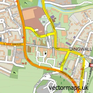
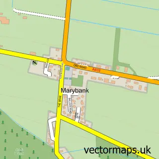
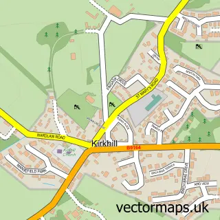
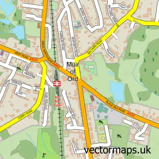
This Maryburgh street map is a detailed vector street map covering a 750m x 750m area. Select a larger area to create and download your own vector street map of Maryburgh.

Maryburgh is a village in Ross And Cromarty, in the Highlands And Islands of Scotland. The settlement falls within the Ross, Skye And Lochaber parliamentary constituency. It is served by the IV7 postcode district, with IV7 8 as the local postcode sector.

The 750-metre map sample for Maryburgh covers 130 mapped buildings and approximately 17.3 km of road detail, of which 15 named roads are named. The immediate area includes 1 GP surgery within 2 miles, 1 pub and 6 MOT stations within 2 miles. The wider area around Maryburgh features 1 food and drink venue and 1 campsite within 2 miles. To create a larger or custom map of Maryburgh, the map builder lets you define your own coverage area and download editable SVG, PDF and PNG files.

130Buildings
17.27 kmRoads
15Named roads
0Residents within 2 miles
Create your own

Create a larger editable map of Maryburgh

Choose any area you need and generate a high-quality vector map instantly. Perfect for print, planning, design, business and personal use.

Choose any location
Editable SVG files
Any size up to A0
PDF, PNG & more
Instant download
High quality guaranteed
Create My Custom Map
Secure, private & no credit card required
Maryburgh Vector Street Map
750m Sample
Maryburgh vector street map sample showing roads, buildings and local features in a 750 metre preview area
Buy Maryburgh Map Print from £12.95 Buy Maryburgh Digital Map from £6

This Maryburgh street map in Ross and Cromarty is available as downloadable SVG, PDF and PNG map files, or as a printed map for planning, business, display, education, local information and design work. You can also create a larger custom map area using the map selector.

What this Maryburgh map sample shows

Maryburgh lies within Highland parish, part of Dingwall And Seaforth ward in the Highland local authority area. The postcode geography for this area includes the IV postcode area, the IV7 postcode district and the IV7 8 postcode sector. Residents fall under the Highland for NHS services.

Local features near Maryburgh

Within 2 miles

Amenities and services in and around Maryburgh.

1 Campsites within 2 miles
1 GP surgeries within 2 miles
6 MOT stations within 2 miles
1 Food & drink
1 Pubs

Counts are approximate and based on publicly available data.

Administrative and postcode information for Maryburgh

Maryburgh lies within Highland parish, part of Dingwall And Seaforth ward in the Highland local authority area. The postcode geography for this area includes the IV postcode area, the IV7 postcode district and the IV7 8 postcode sector. Residents fall under the Highland for NHS services.

Parish HIGHLAND
Ward Dingwall and Seaforth
District / local authority Highland
County Ross and Cromarty
Historic county Ross and Cromarty
Postcode district IV7
Postcode sector IV7 8
Parliamentary constituency Ross, Skye and Lochaber
Region Highlands and Islands
Country Scotland

Nearby street map samples around Maryburgh

Street map sample of Dingwall, Ross and Cromarty Dingwall Town - Ross and Cromarty - 1.5 miles Street map sample of Inverness, Inverness Inverness City - Inverness - 10.4 miles Street map sample of Conon Bridge, Ross and Cromarty Conon Bridge Village - Ross and Cromarty - 0.7 miles Street map sample of Mulbuie, Ross and Cromarty Mulbuie Village - Ross and Cromarty - 2.8 miles Street map sample of Strathpeffer, Ross and Cromarty Strathpeffer Village - Ross and Cromarty - 3.7 miles Street map sample of Marybank, Ross and Cromarty Marybank Village - Ross and Cromarty - 4.1 miles Street map sample of Culbokie, Ross and Cromarty Culbokie Village - Ross and Cromarty - 4.2 miles Street map sample of Tore, Ross and Cromarty Tore Village - Ross and Cromarty - 4.7 miles Street map sample of Contin, Ross and Cromarty Contin Village - Ross and Cromarty - 5.2 miles Street map sample of Kirkhill, Inverness Kirkhill Village - Inverness - 6.9 miles

More street maps in Ross and Cromarty

Street map sample of Conon Bridge, Ross and Cromarty Conon Bridge Village - 0.7 miles Street map sample of Dingwall, Ross and Cromarty Dingwall Town - 1.5 miles Street map sample of Mulbuie, Ross and Cromarty Mulbuie Village - 2.8 miles Street map sample of Strathpeffer, Ross and Cromarty Strathpeffer Village - 3.7 miles Street map sample of Muir of Ord, Ross and Cromarty Muir of Ord Town - 4.0 miles

750 metre map area coverage

Boundary, postcode and point of interest information for the 750m x 750m rectangle centred on this sample map.

Boundaries containing map centre

Constituency: Caithness, Sutherland and Easter Ross Co Const

District: Highland

Icb: Highland

Postcode District: IV7

Postcode Sector: IV7 8

Ward: Dingwall and Seaforth Ward

Nearby boundaries intersecting sample

No additional intersecting boundaries found.

Postcode coverage

IV7 IV7 8

POI category counts

Convenience Store: 3

Professional Services: 2

Advertising Agency: 1

Assisted Living Facility: 1

Auto Detailing: 1

Beauty And Spa: 1

Church Cathedral: 1

Community Center: 1

Driving School: 1

Gastropub: 1

Sample points of interest

  • Core Digital Advertising Agency
  • Seaforth Respite Care Centre Assisted Living Facility
  • Squeaky Clean Mobile Vehicle Valeting Auto Detailing
  • KT Beauty & Aesthetics Beauty And Spa
  • Maryburgh Free Church Church Cathedral
  • Maryburgh Amenities Centre Community Center
  • Premier Convenience Store
  • Premier Maryburgh Stores Convenience Store
  • SPAR Convenience Store
  • Alan Munro Driving Instructor Driving School
  • Cottage Bar & Restaurant Gastropub
  • Empowered Wellbeing Naturopathic Holistic

Create a larger editable map of Maryburgh

This sample shows only a 750 metre area. To create a larger map of Maryburgh, use our map builder to choose your own coverage area, add titles and download editable SVG, PDF and PNG files.

Create a custom map of Maryburgh

Phone 01751 473136 | Copyright Vectormaps.uk 2026

Samples Customizer Privacy Disclaimer
Maryburgh Vector Street Map
Maryburgh enlarged street map sample showing a 750 metre preview area