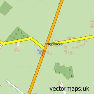
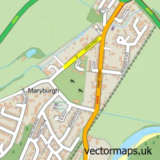
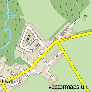
This Muir of Ord street map is a detailed vector street map covering a 750m x 750m area. Select a larger area to create and download your own vector street map of Muir of Ord.
The 750-metre map sample for Muir of Ord covers 173 mapped buildings and approximately 16.3 km of road detail, of which 25 named roads are named. The immediate area includes 1 railway station and 1 MOT station, with 3 within 2 miles. The wider area around Muir of Ord features 2 hotels. To create a larger or custom map of Muir of Ord, the map builder lets you define your own coverage area and download editable SVG, PDF and PNG files.
Create a larger editable map of Muir of Ord
Choose any area you need and generate a high-quality vector map instantly. Perfect for print, planning, design, business and personal use.

This Muir of Ord street map in Ross and Cromarty is available as downloadable SVG, PDF and PNG map files, or as a printed map for planning, business, display, education, local information and design work. You can also create a larger custom map area using the map selector.
What this Muir of Ord map sample shows
Muir of Ord lies within Highland parish, part of Dingwall And Seaforth ward in the Highland local authority area. The postcode geography for this area includes the IV postcode area, the IV6 postcode district and the IV6 7 postcode sector. Residents fall under the Highland for NHS services.
Local features near Muir of Ord
Within 2 milesAmenities and services in and around Muir of Ord.
Administrative and postcode information for Muir of Ord
The local authority covering Muir of Ord is Highland, within the county of Ross And Cromarty. The settlement lies within Dingwall And Seaforth ward and Highland civil parish. The IV6 postcode district and IV6 7 postcode sector serve the immediate area. NHS provision in the area is delivered through Highland.
Nearby street map samples around Muir of Ord

More street maps in Ross and Cromarty
750 metre map area coverage
Boundary, postcode and point of interest information for the 750m x 750m rectangle centred on this sample map.
Boundaries containing map centre
Constituency: Caithness, Sutherland and Easter Ross Co Const
District: Highland
Icb: Highland
Postcode District: IV6
Postcode Sector: IV6 7
Ward: Dingwall and Seaforth Ward
Nearby boundaries intersecting sample
No additional intersecting boundaries found.
Postcode coverage
POI category counts
Convenience Store: 4
Gas Station: 3
Post Office: 3
Beauty Salon: 2
Charity Organization: 2
Funeral Services And Cemeteries: 2
Gym: 2
Hotel: 2
Pharmacy: 2
Train Station: 2
Sample points of interest
- Fairburn Farms
- Bad Girl Bakery
- RBS
- Royal Bank of Scotland
- The Stagger Inn 2021
- Face Facts
- The Vanity Lounge
- Urray and Kilchrist
- Blythswood Care
- Ross and Cromarty Heritage Society
- Urray & Kilchrist Church of Scotland
- Muir of Ord Village Hall
Create a larger editable map of Muir of Ord
This sample shows only a 750 metre area. To create a larger map of Muir of Ord, use our map builder to choose your own coverage area, add titles and download editable SVG, PDF and PNG files.
Create a custom map of Muir of Ord