Vector Maps logo
Home Why it works Popular maps Districts Samples Customizer Create Your Map
VectorMaps.uk
Home Popular maps Districts Samples Customizer Create Your Map Privacy Disclaimer
Home / UK Maps / North Yorkshire / Masham Map

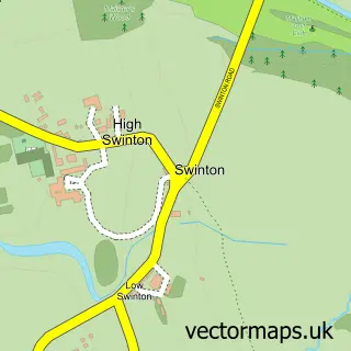
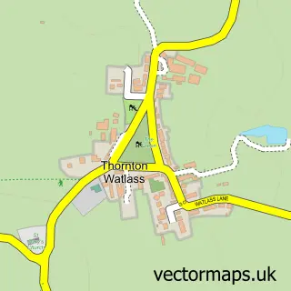
This Masham street map is a detailed vector street map covering a 750m x 750m area. Select a larger area to create and download your own vector street map of Masham.

Masham is a town in North Yorkshire, in the Yorkshire And The Humber of England. Historically, the area formed part of Yorkshire. The settlement falls within the Skipton And Ripon parliamentary constituency. It is served by the HG4 postcode district, with

The 750-metre map sample for Masham covers 307 mapped buildings and approximately 13.6 km of road detail, of which 30 named roads are named. The immediate area includes 1 school, 1 GP surgery, 6 pubs and 1 MOT station. The wider area around Masham features 10 food and drink venues, 4 hotels and 1 campsite within 2 miles. To create a larger or custom map of Masham, the map builder lets you define your own coverage area and download editable SVG, PDF and PNG files.

307Buildings
13.63 kmRoads
30Named roads
677Residents within 2 miles
Create your own

Create a larger editable map of Masham

Choose any area you need and generate a high-quality vector map instantly. Perfect for print, planning, design, business and personal use.

Choose any location
Editable SVG files
Any size up to A0
PDF, PNG & more
Instant download
High quality guaranteed
Create My Custom Map
Secure, private & no credit card required
Masham Vector Street Map
750m Sample
Masham vector street map sample showing roads, buildings and local features in a 750 metre preview area
Buy Masham Map Print from £12.95 Buy Masham Digital Map from £6

This Masham street map in North Yorkshire is available as downloadable SVG, PDF and PNG map files, or as a printed map for planning, business, display, education, local information and design work. You can also create a larger custom map area using the map selector.

What this Masham map sample shows

Masham lies within Masham Cp parish, part of Masham & Kirkby Malzeard ward in the North Yorkshire local authority area. The postcode geography for this area includes the HG postcode area, the HG4 postcode district and the HG4 4 postcode sector. Residents fall under the Nhs Humber And North Yorkshire Integrated Care Board for NHS services.

Local features near Masham

Within 2 miles

Amenities and services in and around Masham.

1 Schools
1 Campsites within 2 miles
1 GP surgeries 1 within 2 miles
1 MOT stations 1 within 2 miles
10 Food & drink
6 Pubs
4 Hotels
3 Healthcare POIs
2 Vehicle services

Counts are approximate and based on publicly available data.

Administrative and postcode information for Masham

Masham lies within Masham Cp parish, part of Masham & Kirkby Malzeard ward in the North Yorkshire local authority area. The postcode geography for this area includes the HG postcode area, the HG4 postcode district and the HG4 4 postcode sector. Residents fall under the Nhs Humber And North Yorkshire Integrated Care Board for NHS services.

Parish Masham CP
Ward Masham & Kirkby Malzeard
District / local authority North Yorkshire
County North Yorkshire
Historic county Yorkshire
Postcode district HG4
Postcode sector HG4 4
Parliamentary constituency Skipton and Ripon
Region Yorkshire and the Humber
Country England

Nearby street map samples around Masham

Street map sample of Ripon, North Yorkshire Ripon City - North Yorkshire - 8.0 miles Street map sample of Swinton, North Yorkshire Swinton Village - North Yorkshire - 0.9 miles Street map sample of Well, North Yorkshire Well Village - North Yorkshire - 2.7 miles Street map sample of Grewelthorpe, North Yorkshire Grewelthorpe Village - North Yorkshire - 2.8 miles Street map sample of West Tanfield, North Yorkshire West Tanfield Village - North Yorkshire - 2.9 miles Street map sample of Mickley, North Yorkshire Mickley Village - North Yorkshire - 3.0 miles Street map sample of Thornton Watlass, North Yorkshire Thornton Watlass Village - North Yorkshire - 3.0 miles Street map sample of Snape, North Yorkshire Snape Village - North Yorkshire - 3.5 miles Street map sample of Kirkby Malzeard, North Yorkshire Kirkby Malzeard Village - North Yorkshire - 4.0 miles Street map sample of Thornborough, North Yorkshire Thornborough Village - North Yorkshire - 4.2 miles

More street maps in North Yorkshire

Street map sample of Swinton, North Yorkshire Swinton Village - 0.9 miles Street map sample of Well, North Yorkshire Well Village - 2.7 miles Street map sample of Grewelthorpe, North Yorkshire Grewelthorpe Village - 2.8 miles Street map sample of West Tanfield, North Yorkshire West Tanfield Village - 2.9 miles Street map sample of Mickley, North Yorkshire Mickley Village - 3.0 miles

750 metre map area coverage

Boundary, postcode and point of interest information for the 750m x 750m rectangle centred on this sample map.

Boundaries containing map centre

Constituency: Skipton and Ripon Co Const

District: North Yorkshire

Icb: NHS Humber and North Yorkshire ICB

Parish: Masham CP

Police Force: north yorkshire

Postcode District: HG4

Postcode Sector: HG4 4

Nearby boundaries intersecting sample

Parish: Burton-on-Yore CP

Postcode coverage

HG4 HG4 4

POI category counts

Pub: 6

Brewery: 4

Church Cathedral: 4

Hotel: 4

Art Gallery: 3

Arts And Crafts: 2

Banks: 2

Cafe: 2

Candy Store: 2

Cottage: 2

Sample points of interest

  • The Square Kitchen American Restaurant
  • Masham: St Mary the Virgin Anglican Church
  • Brocott UK Appliance Store
  • Desiree Hope Gallery Art Gallery
  • Masham Gallery Art Gallery
  • The Nolon Stacey Gallery Art Gallery
  • Each One Unique Arts And Crafts
  • Through the Looking Glass Arts And Crafts
  • Maple Creek Sheltered Housing Assisted Living Facility
  • The Cooperative Food (BF) Masham, Masham Atms
  • Halifax Bank Credit Union
  • Barclays Bank Banks

Create a larger editable map of Masham

This sample shows only a 750 metre area. To create a larger map of Masham, use our map builder to choose your own coverage area, add titles and download editable SVG, PDF and PNG files.

Create a custom map of Masham

Phone 01751 473136 | Copyright Vectormaps.uk 2026

Samples Customizer Privacy Disclaimer
Masham Vector Street Map
Masham enlarged street map sample showing a 750 metre preview area