Vector Maps logo
Home Why it works Popular maps Districts Samples Customizer Create Your Map
VectorMaps.uk
Home Popular maps Districts Samples Customizer Create Your Map Privacy Disclaimer
Home / UK Maps / East Riding of Yorkshire / Melbourne Map

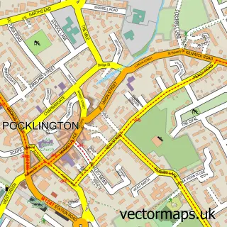
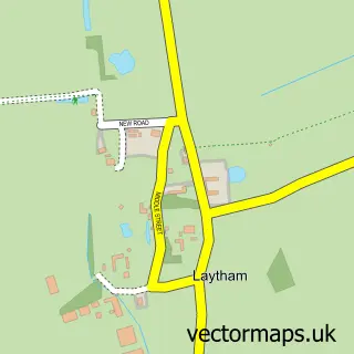
This Melbourne street map is a detailed vector street map covering a 750m x 750m area. Select a larger area to create and download your own vector street map of Melbourne.

Melbourne is a village in East Riding Of Yorkshire, in the Yorkshire And The Humber of England. Historically, the area formed part of Yorkshire. The settlement falls within the East Yorkshire parliamentary constituency. It is served by the YO42 postcode d

The 750-metre map sample for Melbourne covers 227 mapped buildings and approximately 5.3 km of road detail, of which 10 named roads are named. The immediate area includes 1 school, 2 pubs and 1 MOT station within 2 miles. The wider area around Melbourne features 2 food and drink venues. To create a larger or custom map of Melbourne, the map builder lets you define your own coverage area and download editable SVG, PDF and PNG files.

227Buildings
5.26 kmRoads
10Named roads
431Residents within 2 miles
Create your own

Create a larger editable map of Melbourne

Choose any area you need and generate a high-quality vector map instantly. Perfect for print, planning, design, business and personal use.

Choose any location
Editable SVG files
Any size up to A0
PDF, PNG & more
Instant download
High quality guaranteed
Create My Custom Map
Secure, private & no credit card required
Melbourne Vector Street Map
750m Sample
Melbourne vector street map sample showing roads, buildings and local features in a 750 metre preview area
Buy Melbourne Map Print from £12.95 Buy Melbourne Digital Map from £6

This Melbourne street map in East Riding of Yorkshire is available as downloadable SVG, PDF and PNG map files, or as a printed map for planning, business, display, education, local information and design work. You can also create a larger custom map area using the map selector.

What this Melbourne map sample shows

Melbourne lies within Melbourne Cp parish, part of Wolds Weighton ward in the East Riding Of Yorkshire local authority area. The postcode geography for this area includes the YO postcode area, the YO42 postcode district and the YO42 4 postcode sector. Residents fall under the Nhs Humber And North Yorkshire Integrated Care Board for NHS services.

Local features near Melbourne

Within 2 miles

Amenities and services in and around Melbourne.

1 Schools
1 MOT stations within 2 miles
2 Food & drink
2 Pubs

Counts are approximate and based on publicly available data.

Administrative and postcode information for Melbourne

Melbourne lies within Melbourne Cp parish, part of Wolds Weighton ward in the East Riding Of Yorkshire local authority area. The postcode geography for this area includes the YO postcode area, the YO42 postcode district and the YO42 4 postcode sector. Residents fall under the Nhs Humber And North Yorkshire Integrated Care Board for NHS services.

Parish Melbourne CP
Ward Wolds Weighton
District / local authority East Riding of Yorkshire
County East Riding of Yorkshire
Historic county Yorkshire
Postcode district YO42
Postcode sector YO42 4
Parliamentary constituency East Yorkshire
Region Yorkshire and the Humber
Country England

Nearby street map samples around Melbourne

Street map sample of Pocklington, East Riding of Yorkshire Pocklington Town - East Riding of Yorkshire - 4.5 miles Street map sample of York, North Yorkshire York City - North Yorkshire - 10.3 miles Street map sample of Thornton, East Riding of Yorkshire Thornton Village - East Riding of Yorkshire - 0.8 miles Street map sample of Bielby, East Riding of Yorkshire Bielby Village - East Riding of Yorkshire - 2.3 miles Street map sample of Seaton Ross, East Riding of Yorkshire Seaton Ross Village - East Riding of Yorkshire - 2.6 miles Street map sample of Allerthorpe, East Riding of Yorkshire Allerthorpe Village - East Riding of Yorkshire - 2.8 miles Street map sample of Laytham, East Riding of Yorkshire Laytham Village - East Riding of Yorkshire - 2.8 miles Street map sample of East Cottingwith, East Riding of Yorkshire East Cottingwith Village - East Riding of Yorkshire - 3.1 miles Street map sample of Sutton Upon Derwent, East Riding of Yorkshire Sutton Upon Derwent Village - East Riding of Yorkshire - 3.2 miles Street map sample of Barmby Moor, East Riding of Yorkshire Barmby Moor Village - East Riding of Yorkshire - 3.2 miles

More street maps in East Riding of Yorkshire

Street map sample of Thornton, East Riding of Yorkshire Thornton Village - 0.8 miles Street map sample of Bielby, East Riding of Yorkshire Bielby Village - 2.3 miles Street map sample of Seaton Ross, East Riding of Yorkshire Seaton Ross Village - 2.6 miles Street map sample of Allerthorpe, East Riding of Yorkshire Allerthorpe Village - 2.8 miles Street map sample of Laytham, East Riding of Yorkshire Laytham Village - 2.8 miles

750 metre map area coverage

Boundary, postcode and point of interest information for the 750m x 750m rectangle centred on this sample map.

Boundaries containing map centre

Constituency: Goole and Pocklington Co Const

District: East Riding of Yorkshire

Icb: NHS Humber and North Yorkshire ICB

Parish: Melbourne CP

Police Force: humberside

Postcode District: YO42

Postcode Sector: YO42 4

Ward: Wolds Weighton Ward

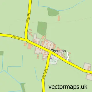
Nearby boundaries intersecting sample

Parish: Thornton CP

Postcode coverage

YO42 YO42 4

POI category counts

Elementary School: 2

Pub: 2

Active Life: 1

Advertising Agency: 1

Auto Detailing: 1

Church Cathedral: 1

Fence And Gate Sales Service: 1

Hair Salon: 1

Metal Supplier: 1

Physical Therapy: 1

Sample points of interest

  • Pocklington Canal, starting at Melbourne Moorings Active Life
  • Red Bonsai Advertising Agency
  • Reflective Detailing Auto Detailing
  • Melbourne Methodist Church Church Cathedral
  • Melbourne Community Primary School Elementary School
  • Melbourne Community Primary School Elementary School
  • J.M Fencing & Gates Fence And Gate Sales Service
  • Katrina Smith Hair Hair Salon
  • P Slater Engineering Metal Supplier
  • Melbourne Arm Marina Physical Therapy
  • Melbourne Post Office Post Office
  • Melbourne Arms Pub

Create a larger editable map of Melbourne

This sample shows only a 750 metre area. To create a larger map of Melbourne, use our map builder to choose your own coverage area, add titles and download editable SVG, PDF and PNG files.

Create a custom map of Melbourne

Phone 01751 473136 | Copyright Vectormaps.uk 2026

Samples Customizer Privacy Disclaimer
Melbourne Vector Street Map
Melbourne enlarged street map sample showing a 750 metre preview area