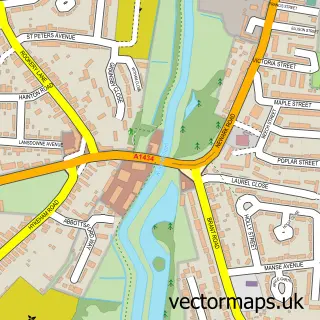
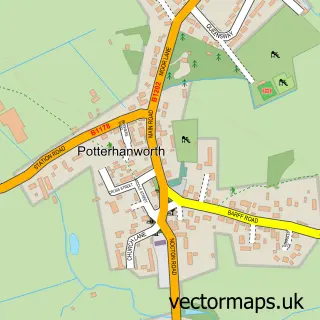
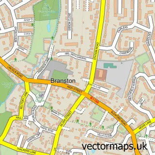
This Metheringham street map is a detailed vector street map covering a 750m x 750m area. Select a larger area to create and download your own vector street map of Metheringham.
The 750-metre map sample for Metheringham covers 604 mapped buildings and approximately 17.4 km of road detail, of which 41 named roads are named. The immediate area includes 1 school, 1 GP surgery, 4 pubs and 2 MOT stations within 2 miles. The wider area around Metheringham features 2 tourism points of interest and 7 food and drink venues. To create a larger or custom map of Metheringham, the map builder lets you define your own coverage area and download editable SVG, PDF and PNG files.
Create a larger editable map of Metheringham
Choose any area you need and generate a high-quality vector map instantly. Perfect for print, planning, design, business and personal use.

This Metheringham street map in Lincolnshire is available as downloadable SVG, PDF and PNG map files, or as a printed map for planning, business, display, education, local information and design work. You can also create a larger custom map area using the map selector.
What this Metheringham map sample shows
Metheringham lies within Metheringham Cp parish, part of Metheringham ward in the North Kesteven District local authority area. The postcode geography for this area includes the LN postcode area, the LN4 postcode district and the LN4 3 postcode sector. Residents fall under the Nhs Lincolnshire Integrated Care Board for NHS services.
Local features near Metheringham
Within 2 milesAmenities and services in and around Metheringham.
Administrative and postcode information for Metheringham
The local authority covering Metheringham is North Kesteven District, within the county of Lincolnshire. The settlement lies within Metheringham ward and Metheringham Cp civil parish. The LN4 postcode district and LN4 3 postcode sector serve the immediate area. NHS provision in the area is delivered through United Lincolnshire Hospitals Nhs Trust.
Nearby street map samples around Metheringham

More street maps in Lincolnshire
750 metre map area coverage
Boundary, postcode and point of interest information for the 750m x 750m rectangle centred on this sample map.
Boundaries containing map centre
Constituency: Sleaford and North Hykeham Co Const
County: Lincolnshire County
District: North Kesteven District
Icb: NHS Lincolnshire ICB
Parish: Metheringham CP
Police Force: lincolnshire
Postcode District: LN4
Postcode Sector: LN4 3
Ward: Metheringham Rural Ward
Nearby boundaries intersecting sample
No additional intersecting boundaries found.
Postcode coverage
POI category counts
Convenience Store: 4
Indian Restaurant: 4
Professional Services: 4
Pub: 4
Church Cathedral: 3
Gas Station: 3
Pizza Restaurant: 3
Bar: 2
Beauty Salon: 2
Cafe: 2
Sample points of interest
- Wright Lilley & Co.
- Metheringham Airfield
- Budget Appliance Spares
- Mirchi
- The Haven Residential Home
- Lincolnshire Co-op - Metheringham (001006), Metheringham
- Metheringham Bowls Club
- Star and Garter Pub (Metheringham)
- Karens Kuts
- Ecco Hair Salon
- Emily's Tanning & Beauty
- Green Electrical Solutions
Create a larger editable map of Metheringham
This sample shows only a 750 metre area. To create a larger map of Metheringham, use our map builder to choose your own coverage area, add titles and download editable SVG, PDF and PNG files.
Create a custom map of Metheringham