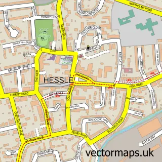
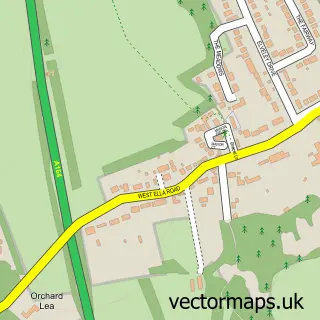
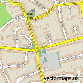
This North Ferriby street map is a detailed vector street map covering a 750m x 750m area. Select a larger area to create and download your own vector street map of North Ferriby.
The 750-metre map sample for North Ferriby covers 461 mapped buildings and approximately 12.5 km of road detail, of which 35 named roads are named. The immediate area includes 1 school, 1 railway station, 1 GP surgery and 3 MOT stations within 2 miles. The wider area around North Ferriby features 2 tourism points of interest, 2 food and drink venues and 1 hotel. To create a larger or custom map of North Ferriby, the map builder lets you define your own coverage area and download editable SVG, PDF and PNG files.
Create a larger editable map of North Ferriby
Choose any area you need and generate a high-quality vector map instantly. Perfect for print, planning, design, business and personal use.

This North Ferriby street map in East Riding of Yorkshire is available as downloadable SVG, PDF and PNG map files, or as a printed map for planning, business, display, education, local information and design work. You can also create a larger custom map area using the map selector.
What this North Ferriby map sample shows
North Ferriby lies within North Ferriby Cp parish, part of South Hunsley ward in the East Riding Of Yorkshire local authority area. The postcode geography for this area includes the HU postcode area, the HU14 postcode district and the HU14 3 postcode sector. Residents fall under the Nhs Humber And North Yorkshire Integrated Care Board for NHS services.
Local features near North Ferriby
Within 2 milesAmenities and services in and around North Ferriby.
Administrative and postcode information for North Ferriby
North Ferriby lies within North Ferriby Cp parish, part of South Hunsley ward in the East Riding Of Yorkshire local authority area. The postcode geography for this area includes the HU postcode area, the HU14 postcode district and the HU14 3 postcode sector. Residents fall under the Nhs Humber And North Yorkshire Integrated Care Board for NHS services.
Nearby street map samples around North Ferriby

More street maps in East Riding of Yorkshire
750 metre map area coverage
Boundary, postcode and point of interest information for the 750m x 750m rectangle centred on this sample map.
Boundaries containing map centre
Constituency: Goole and Pocklington Co Const
District: East Riding of Yorkshire
Icb: NHS Humber and North Yorkshire ICB
Parish: North Ferriby CP
Police Force: humberside
Postcode District: HU14
Postcode Sector: HU14 3
Ward: South Hunsley Ward
Nearby boundaries intersecting sample
No additional intersecting boundaries found.
Postcode coverage
POI category counts
Beauty Salon: 5
Beauty And Spa: 3
Mortgage Broker: 3
Train Station: 3
Convenience Store: 2
Elementary School: 2
Hair Salon: 2
Soccer Stadium: 2
Sports Club And League: 2
Advertising Agency: 1
Sample points of interest
- Melton Mobile Media
- All Saints' North Ferriby
- Tom Harland
- Riverside Walkway
- M&A Barber studio
- Gold Aesthetics
- Limone aesthetics and beauty
- The Hideaway by Caroline Thomas
- Be Hair & Beauty
- Beauty969
- Hair by Kayleigh at Be Hair & Beauty
- KTS Hair & Nails
Create a larger editable map of North Ferriby
This sample shows only a 750 metre area. To create a larger map of North Ferriby, use our map builder to choose your own coverage area, add titles and download editable SVG, PDF and PNG files.
Create a custom map of North Ferriby