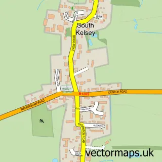
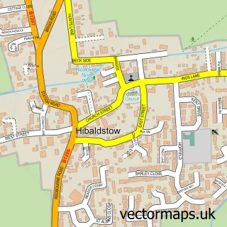
This North Kelsey street map is a detailed vector street map covering a 750m x 750m area. Select a larger area to create and download your own vector street map of North Kelsey.
The 750-metre map sample for North Kelsey covers 363 mapped buildings and approximately 24.3 km of road detail, of which 24 named roads are named. The immediate area includes 1 school and 1 pub. The wider area around North Kelsey features 1 food and drink venue and 1 hotel. To create a larger or custom map of North Kelsey, the map builder lets you define your own coverage area and download editable SVG, PDF and PNG files.
Create a larger editable map of North Kelsey
Choose any area you need and generate a high-quality vector map instantly. Perfect for print, planning, design, business and personal use.

This North Kelsey street map in Lincolnshire is available as downloadable SVG, PDF and PNG map files, or as a printed map for planning, business, display, education, local information and design work. You can also create a larger custom map area using the map selector.
What this North Kelsey map sample shows
North Kelsey lies within North Kelsey Cp parish, part of Kelsey Wold ward in the West Lindsey District local authority area. The postcode geography for this area includes the LN postcode area, the LN7 postcode district and the LN7 6 postcode sector. Residents fall under the Nhs Lincolnshire Integrated Care Board for NHS services.
Local features near North Kelsey
Within 2 milesAmenities and services in and around North Kelsey.
Administrative and postcode information for North Kelsey
The local authority covering North Kelsey is West Lindsey District, within the county of Lincolnshire. The settlement lies within Kelsey Wold ward and North Kelsey Cp civil parish. The LN7 postcode district and LN7 6 postcode sector serve the immediate area. NHS provision in the area is delivered through Northern Lincolnshire And Goole Nhs Foundation Trust.
Nearby street map samples around North Kelsey

More street maps in Lincolnshire
750 metre map area coverage
Boundary, postcode and point of interest information for the 750m x 750m rectangle centred on this sample map.
Boundaries containing map centre
Constituency: Gainsborough Co Const
County: Lincolnshire County
District: West Lindsey District
Icb: NHS Lincolnshire ICB
Parish: North Kelsey CP
Police Force: lincolnshire
Postcode District: LN7
Postcode Sector: LN7 6
Ward: Kelsey Wold Ward
Nearby boundaries intersecting sample
No additional intersecting boundaries found.
Postcode coverage
POI category counts
Motorcycle Repair: 2
Shipping Center: 2
Automotive Repair: 1
Church Cathedral: 1
Community Center: 1
Construction Services: 1
Doctor: 1
Education: 1
Electrician: 1
Elementary School: 1
Sample points of interest
- Redline Track
- All Hallows Church
- North Kelsey Village Hall
- JM Building Services
- Slimming World in Market Rasen & Caistor
- Redfearn Training
- Jet Lightening Electrical
- Kelsey Primary School
- The Grand Hotel Scarborough
- The Heat Source
- CMR Classic Racing & Restoration
- Fast Lane Head Work
Create a larger editable map of North Kelsey
This sample shows only a 750 metre area. To create a larger map of North Kelsey, use our map builder to choose your own coverage area, add titles and download editable SVG, PDF and PNG files.
Create a custom map of North Kelsey