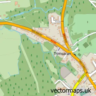
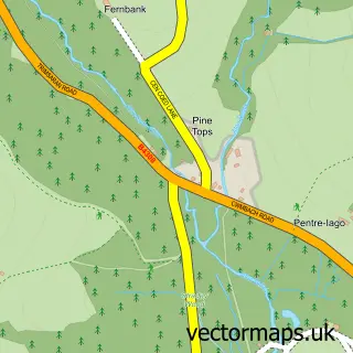
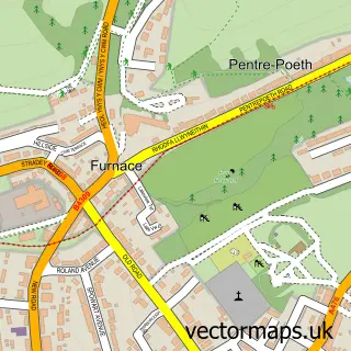
This Pembrey street map is a detailed vector street map covering a 750m x 750m area. Select a larger area to create and download your own vector street map of Pembrey.
The 750-metre map sample for Pembrey covers 300 mapped buildings and approximately 11.5 km of road detail, of which 17 named roads are named. The immediate area includes 1 school, 2 pubs and 1 MOT station, with 3 within 2 miles. The wider area around Pembrey features 2 tourism points of interest, 3 food and drink venues and 2 hotels. To create a larger or custom map of Pembrey, the map builder lets you define your own coverage area and download editable SVG, PDF and PNG files.
Create a larger editable map of Pembrey
Choose any area you need and generate a high-quality vector map instantly. Perfect for print, planning, design, business and personal use.

This Pembrey street map in Dyfed is available as downloadable SVG, PDF and PNG map files, or as a printed map for planning, business, display, education, local information and design work. You can also create a larger custom map area using the map selector.
What this Pembrey map sample shows
Pembrey lies within Pembrey And Burry Port Town Community parish, part of Pembrey ward in the Sir Gaerfyrddin - Carmarthenshire local authority area. The postcode geography for this area includes the SA postcode area, the SA16 postcode district and the SA16 0 postcode sector. Residents fall under the Hywel Dda University Health Board for NHS services.
Local features near Pembrey
Within 2 milesAmenities and services in and around Pembrey.
Administrative and postcode information for Pembrey
Pembrey lies within Pembrey And Burry Port Town Community parish, part of Pembrey ward in the Sir Gaerfyrddin - Carmarthenshire local authority area. The postcode geography for this area includes the SA postcode area, the SA16 postcode district and the SA16 0 postcode sector. Residents fall under the Hywel Dda University Health Board for NHS services.
Nearby street map samples around Pembrey

More street maps in Dyfed
750 metre map area coverage
Boundary, postcode and point of interest information for the 750m x 750m rectangle centred on this sample map.
Boundaries containing map centre
Constituency: Llanelli Co Const
District: Sir Gaerfyrddin - Carmarthenshire
Icb: Hywel Dda
Parish: Pembrey and Burry Port Town Community
Police Force: dyfed-powys
Postcode District: SA16
Postcode Sector: SA16 0
Nearby boundaries intersecting sample
No additional intersecting boundaries found.
Postcode coverage
POI category counts
Automotive Repair: 3
Hotel: 2
Pub: 2
American Restaurant: 1
Art Gallery: 1
Bed And Breakfast: 1
Car Dealer: 1
Carpet Store: 1
Church Cathedral: 1
Coffee Shop: 1
Sample points of interest
- Amelia's Café
- Pembrey Pottery
- AKL Autos school garage
- Chris Composites
- Tint My Ride
- Adeline Guest House
- My-Motor
- First Choice Flooring
- St. Illtyd Church
- Pantri Lolfa
- Drifters Cottage Holiday Let
- Talking Heads Therapy
Create a larger editable map of Pembrey
This sample shows only a 750 metre area. To create a larger map of Pembrey, use our map builder to choose your own coverage area, add titles and download editable SVG, PDF and PNG files.
Create a custom map of Pembrey