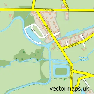
This Penkridge street map is a detailed vector street map covering a 750m x 750m area. Select a larger area to create and download your own vector street map of Penkridge.
The 750-metre map sample for Penkridge covers 448 mapped buildings and approximately 16.8 km of road detail, of which 45 named roads are named. The immediate area includes 3 schools, 1 GP surgery within 2 miles, 7 pubs and 1 MOT station, with 2 within 2 miles. The wider area around Penkridge features 2 tourism points of interest, 13 food and drink venues and 1 hotel. To create a larger or custom map of Penkridge, the map builder lets you define your own coverage area and download editable SVG, PDF and PNG files.
Create a larger editable map of Penkridge
Choose any area you need and generate a high-quality vector map instantly. Perfect for print, planning, design, business and personal use.

This Penkridge street map in Staffordshire is available as downloadable SVG, PDF and PNG map files, or as a printed map for planning, business, display, education, local information and design work. You can also create a larger custom map area using the map selector.
What this Penkridge map sample shows
Penkridge lies within Penkridge Cp parish, part of Penkridge North East And Acton Trussell ward in the South Staffordshire District local authority area. The postcode geography for this area includes the ST postcode area, the ST19 postcode district and the ST19 5 postcode sector. Residents fall under the Nhs Staffordshire And Stoke-On-Trent Integrated Care Board for NHS services.
Local features near Penkridge
Within 2 milesAmenities and services in and around Penkridge.
Administrative and postcode information for Penkridge
Penkridge lies within Penkridge Cp parish, part of Penkridge North East And Acton Trussell ward in the South Staffordshire District local authority area. The postcode geography for this area includes the ST postcode area, the ST19 postcode district and the ST19 5 postcode sector. Residents fall under the Nhs Staffordshire And Stoke-On-Trent Integrated Care Board for NHS services.
Nearby street map samples around Penkridge


More street maps in Staffordshire
750 metre map area coverage
Boundary, postcode and point of interest information for the 750m x 750m rectangle centred on this sample map.
Boundaries containing map centre
Constituency: Stone, Great Wyrley and Penkridge Co Const
County: Staffordshire County
District: South Staffordshire District
Icb: NHS Staffordshire and Stoke-on-Trent ICB
Parish: Penkridge CP
Police Force: staffordshire
Postcode District: ST19
Postcode Sector: ST19 5
Ward: Penkridge North & Acton Trussell Ward
Nearby boundaries intersecting sample
Ward: Penkridge South & Gailey Ward
Postcode coverage
POI category counts
Beauty Salon: 7
Hair Salon: 7
Pub: 7
Professional Services: 5
Funeral Services And Cemeteries: 4
Grocery Store: 4
Restaurant: 4
Bar: 3
Butcher Shop: 3
Church Cathedral: 3
Sample points of interest
- We Crunch the Numbers
- Russ James Design
- St Michael's Penkridge.
- The United Deaf Church
- Catherine House Hospice Shop
- LB Appliance Repair
- Riverside House
- Cuttlestones Auctioneers and Valuers
- Family of Five
- Jaspers Village Bakery
- Nationwide
- Nationwide Building Society
Create a larger editable map of Penkridge
This sample shows only a 750 metre area. To create a larger map of Penkridge, use our map builder to choose your own coverage area, add titles and download editable SVG, PDF and PNG files.
Create a custom map of Penkridge