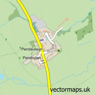
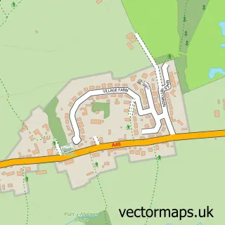
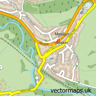
This Peterston-super-Ely street map is a detailed vector street map covering a 750m x 750m area. Select a larger area to create and download your own vector street map of Peterston-super-Ely.
The 750-metre map sample for Peterston-super-Ely covers 135 mapped buildings and approximately 7.9 km of road detail, of which 8 named roads are named. The immediate area includes 1 school and 1 pub. The wider area around Peterston-super-Ely features 2 tourism points of interest and 2 food and drink venues. To create a larger or custom map of Peterston-super-Ely, the map builder lets you define your own coverage area and download editable SVG, PDF and PNG files.
Create a larger editable map of Peterston-super-Ely
Choose any area you need and generate a high-quality vector map instantly. Perfect for print, planning, design, business and personal use.

This Peterston-super-Ely street map in South Glamorgan is available as downloadable SVG, PDF and PNG map files, or as a printed map for planning, business, display, education, local information and design work. You can also create a larger custom map area using the map selector.
What this Peterston-super-Ely map sample shows
Peterston-super-Ely lies within Peterston-Super-Ely Community parish, part of Peterston-Super-Ely ward in the Bro Morgannwg - The Vale Of Glamorgan local authority area. The postcode geography for this area includes the CF postcode area, the CF5 postcode district and the CF5 6 postcode sector. Residents fall under the Cardiff And Vale University Health Board for NHS services.
Local features near Peterston-super-Ely
Within 2 milesAmenities and services in and around Peterston-super-Ely.
Administrative and postcode information for Peterston-super-Ely
Peterston-super-Ely lies within Peterston-Super-Ely Community parish, part of Peterston-Super-Ely ward in the Bro Morgannwg - The Vale Of Glamorgan local authority area. The postcode geography for this area includes the CF postcode area, the CF5 postcode district and the CF5 6 postcode sector. Residents fall under the Cardiff And Vale University Health Board for NHS services.
Nearby street map samples around Peterston-super-Ely

More street maps in South Glamorgan
750 metre map area coverage
Boundary, postcode and point of interest information for the 750m x 750m rectangle centred on this sample map.
Boundaries containing map centre
Constituency: Vale of Glamorgan Co Const
District: Bro Morgannwg - the Vale of Glamorgan
Icb: Cardiff and Vale University
Parish: Peterston-super-Ely Community
Police Force: south wales
Postcode District: CF5
Postcode Sector: CF5 6
Nearby boundaries intersecting sample
No additional intersecting boundaries found.
Postcode coverage
POI category counts
Beauty Salon: 1
Castle: 1
Church Cathedral: 1
Elementary School: 1
Home Service: 1
Landmark And Historical Building: 1
Playground: 1
Pub: 1
Restaurant: 1
Shipping Center: 1
Sample points of interest
- Phoebe’s
- Peterston Castle
- St Peter's Church
- Peterston Super Ely Church in Wales Primary School
- Simply Out of School Peterston
- Lanlay
- Peterston-super-Ely playground
- Sportsmans Rest
- Sportsman's Rest
- Post Office-Peterston-Super-Ely
Create a larger editable map of Peterston-super-Ely
This sample shows only a 750 metre area. To create a larger map of Peterston-super-Ely, use our map builder to choose your own coverage area, add titles and download editable SVG, PDF and PNG files.
Create a custom map of Peterston-super-Ely