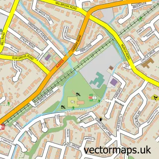
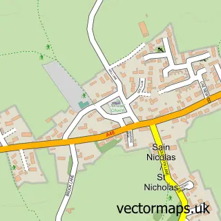
This Wenvoe street map is a detailed vector street map covering a 750m x 750m area. Select a larger area to create and download your own vector street map of Wenvoe.
The 750-metre map sample for Wenvoe covers 310 mapped buildings and approximately 12.2 km of road detail, of which 24 named roads are named. The immediate area includes 1 school, 1 GP surgery within 2 miles, 2 pubs and 6 MOT stations within 2 miles. The wider area around Wenvoe features 2 food and drink venues. To create a larger or custom map of Wenvoe, the map builder lets you define your own coverage area and download editable SVG, PDF and PNG files.
Create a larger editable map of Wenvoe
Choose any area you need and generate a high-quality vector map instantly. Perfect for print, planning, design, business and personal use.

This Wenvoe street map in South Glamorgan is available as downloadable SVG, PDF and PNG map files, or as a printed map for planning, business, display, education, local information and design work. You can also create a larger custom map area using the map selector.
What this Wenvoe map sample shows
Wenvoe lies within Wenvoe Community parish, part of Wenvoe ward in the Bro Morgannwg - The Vale Of Glamorgan local authority area. The postcode geography for this area includes the CF postcode area, the CF5 postcode district and the CF5 6 postcode sector. Residents fall under the Cardiff And Vale University Health Board for NHS services.
Local features near Wenvoe
Within 2 milesAmenities and services in and around Wenvoe.
Administrative and postcode information for Wenvoe
The local authority covering Wenvoe is Bro Morgannwg - The Vale Of Glamorgan, within the county of South Glamorgan. The settlement lies within Wenvoe ward and Wenvoe Community civil parish. The CF5 postcode district and CF5 6 postcode sector serve the immediate area. NHS provision in the area is delivered through Cardiff And Vale University Health Board.
Nearby street map samples around Wenvoe


More street maps in South Glamorgan
750 metre map area coverage
Boundary, postcode and point of interest information for the 750m x 750m rectangle centred on this sample map.
Boundaries containing map centre
Constituency: Vale of Glamorgan Co Const
District: Bro Morgannwg - the Vale of Glamorgan
Icb: Cardiff and Vale University
Parish: Wenvoe Community
Police Force: south wales
Postcode District: CF5
Postcode Sector: CF5 6
Nearby boundaries intersecting sample
No additional intersecting boundaries found.
Postcode coverage
POI category counts
Convenience Store: 2
Professional Services: 2
Pub: 2
Shipping Center: 2
Assisted Living Facility: 1
Beach Equipment Rentals: 1
Beauty And Spa: 1
Building Supply Store: 1
Cabin: 1
Child Care And Day Care: 1
Sample points of interest
- Glenburnie Lodge
- Marquee And Furniture Company
- Nails By Olivia Louise
- Simply Fill Skip Hire
- Springfield Court Apartments
- Wenvoe Playgroup
- St Mary's Church
- Wenvoe Village Hall
- Wenvoe Community Council
- Premier
- Premier Springfield Stores
- Teach Therapy
Create a larger editable map of Wenvoe
This sample shows only a 750 metre area. To create a larger map of Wenvoe, use our map builder to choose your own coverage area, add titles and download editable SVG, PDF and PNG files.
Create a custom map of Wenvoe