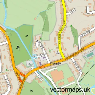
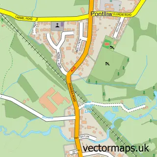
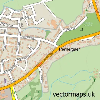
This Pontarddulais street map is a detailed vector street map covering a 750m x 750m area. Select a larger area to create and download your own vector street map of Pontarddulais.
The 750-metre map sample for Pontarddulais covers 457 mapped buildings and approximately 17.7 km of road detail, of which 34 named roads are named. The immediate area includes 1 railway station, 2 pubs and 1 MOT station, with 3 within 2 miles. The wider area around Pontarddulais features 2 tourism points of interest and 8 food and drink venues. To create a larger or custom map of Pontarddulais, the map builder lets you define your own coverage area and download editable SVG, PDF and PNG files.
Create a larger editable map of Pontarddulais
Choose any area you need and generate a high-quality vector map instantly. Perfect for print, planning, design, business and personal use.

This Pontarddulais street map in West Glamorgan is available as downloadable SVG, PDF and PNG map files, or as a printed map for planning, business, display, education, local information and design work. You can also create a larger custom map area using the map selector.
What this Pontarddulais map sample shows
Pontarddulais lies within Pontarddulais Community parish, part of Pontardulais ward in the Abertawe - Swansea local authority area. The postcode geography for this area includes the SA postcode area, the SA4 postcode district and the SA4 8 postcode sector. Residents fall under the Swansea Bay University Local Health Board for NHS services.
Local features near Pontarddulais
Within 2 milesAmenities and services in and around Pontarddulais.
Administrative and postcode information for Pontarddulais
The local authority covering Pontarddulais is Abertawe - Swansea, within the county of West Glamorgan. The settlement lies within Pontardulais ward and Pontarddulais Community civil parish. The SA4 postcode district and SA4 8 postcode sector serve the immediate area. NHS provision in the area is delivered through Swansea Bay University Health Board.
Nearby street map samples around Pontarddulais

More street maps in West Glamorgan
750 metre map area coverage
Boundary, postcode and point of interest information for the 750m x 750m rectangle centred on this sample map.
Boundaries containing map centre
Constituency: Gower Co Const
District: Abertawe - Swansea
Icb: Abertawe Bro Morgannwg University
Parish: Pontarddulais Community
Police Force: south wales
Postcode District: SA4
Postcode Sector: SA4 8
Nearby boundaries intersecting sample
Constituency: Llanelli Co Const
District: Sir Gaerfyrddin - Carmarthenshire
Icb: Hywel Dda
Parish: Llanedi Community
Postcode coverage
POI category counts
Bakery: 5
Bridal Shop: 5
Church Cathedral: 4
Gas Station: 4
Hair Salon: 4
Indian Restaurant: 4
Arts And Crafts: 3
Banks: 3
Beauty Salon: 3
Community Center: 3
Sample points of interest
- Janet D Jenkins Ltd
- The Emporium
- A Good Yarn
- Crefftau y Bont
- The Art Room Bont
- W E Williams
- PayPoint
- Ross Car Sales - German Car Centre
- John Rickard Motor Factors
- Bec the Bake
- David Jenkins
- Jenkins David Bakers Confectioners
Create a larger editable map of Pontarddulais
This sample shows only a 750 metre area. To create a larger map of Pontarddulais, use our map builder to choose your own coverage area, add titles and download editable SVG, PDF and PNG files.
Create a custom map of Pontarddulais