This Ponterwyd street map is a detailed vector street map covering a 750m x 750m area. Select a larger area to create and download your own vector street map of Ponterwyd.
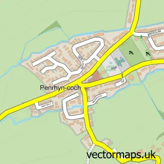
The 750-metre map sample for Ponterwyd covers 113 mapped buildings and approximately 13.1 km of road detail, of which 2 named roads are named. The immediate area includes 1 school. The wider area around Ponterwyd features 1 tourism point of interest and 2 hotels. To create a larger or custom map of Ponterwyd, the map builder lets you define your own coverage area and download editable SVG, PDF and PNG files.
Create a larger editable map of Ponterwyd
Choose any area you need and generate a high-quality vector map instantly. Perfect for print, planning, design, business and personal use.

This Ponterwyd street map in Dyfed is available as downloadable SVG, PDF and PNG map files, or as a printed map for planning, business, display, education, local information and design work. You can also create a larger custom map area using the map selector.
What this Ponterwyd map sample shows
Ponterwyd lies within Blaenrheidol Community parish, part of Melindwr ward in the Sir Ceredigion - Ceredigion local authority area. The postcode geography for this area includes the SY postcode area, the SY23 postcode district and the SY23 3 postcode sector. Residents fall under the Hywel Dda University Health Board for NHS services.
Local features near Ponterwyd
Within 2 milesAmenities and services in and around Ponterwyd.
Administrative and postcode information for Ponterwyd
Ponterwyd lies within Blaenrheidol Community parish, part of Melindwr ward in the Sir Ceredigion - Ceredigion local authority area. The postcode geography for this area includes the SY postcode area, the SY23 postcode district and the SY23 3 postcode sector. Residents fall under the Hywel Dda University Health Board for NHS services.
Nearby street map samples around Ponterwyd

More street maps in Dyfed
750 metre map area coverage
Boundary, postcode and point of interest information for the 750m x 750m rectangle centred on this sample map.
Boundaries containing map centre
Constituency: Ceredigion Preseli Co Const
District: Sir Ceredigion - Ceredigion
Icb: Hywel Dda
Parish: Blaenrheidol Community
Police Force: dyfed-powys
Postcode District: SY23
Postcode Sector: SY23 3
Nearby boundaries intersecting sample
No additional intersecting boundaries found.
Postcode coverage
POI category counts
Convenience Store: 2
Hotel: 2
Active Life: 1
Auto Body Shop: 1
Auto Customization: 1
Gas Station: 1
Landmark And Historical Building: 1
Truck Gas Station: 1
Sample points of interest
- Strata Florida Way
- Loadrated LTD
- Hydro Customs
- Premier
- Premier Siop Rheidol
- BP
- Dolcarne holiday cottages
- George Borrow Hotel
- Llywernog Silver-Lead Mine
- RHEIDOL FILLING STATION
Create a larger editable map of Ponterwyd
This sample shows only a 750 metre area. To create a larger map of Ponterwyd, use our map builder to choose your own coverage area, add titles and download editable SVG, PDF and PNG files.
Create a custom map of Ponterwyd