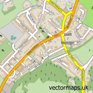
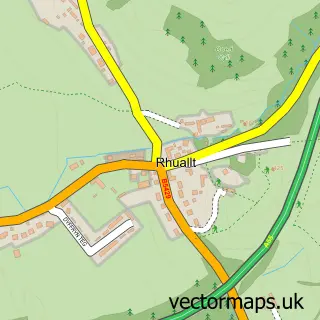
This Rhuddlan street map is a detailed vector street map covering a 750m x 750m area. Select a larger area to create and download your own vector street map of Rhuddlan.
The 750-metre map sample for Rhuddlan covers 551 mapped buildings and approximately 17.7 km of road detail, of which 41 named roads are named. The immediate area includes 1 school, 1 GP surgery, with 2 within 2 miles, 6 pubs and 1 MOT station, with 9 within 2 miles. The wider area around Rhuddlan features 3 tourism points of interest, 13 food and drink venues and 1 hotel. To create a larger or custom map of Rhuddlan, the map builder lets you define your own coverage area and download editable SVG, PDF and PNG files.
Create a larger editable map of Rhuddlan
Choose any area you need and generate a high-quality vector map instantly. Perfect for print, planning, design, business and personal use.

This Rhuddlan street map in Clwyd is available as downloadable SVG, PDF and PNG map files, or as a printed map for planning, business, display, education, local information and design work. You can also create a larger custom map area using the map selector.
What this Rhuddlan map sample shows
Rhuddlan lies within Rhuddlan Community parish, part of Rhuddlan ward in the Sir Ddinbych - Denbighshire local authority area. The postcode geography for this area includes the LL postcode area, the LL18 postcode district and the LL18 6 postcode sector. Residents fall under the Betsi Cadwaladr University Health Board for NHS services.
Local features near Rhuddlan
Within 2 milesAmenities and services in and around Rhuddlan.
Administrative and postcode information for Rhuddlan
Rhuddlan lies within Rhuddlan Community parish, part of Rhuddlan ward in the Sir Ddinbych - Denbighshire local authority area. The postcode geography for this area includes the LL postcode area, the LL18 postcode district and the LL18 6 postcode sector. Residents fall under the Betsi Cadwaladr University Health Board for NHS services.
Nearby street map samples around Rhuddlan

More street maps in Clwyd
750 metre map area coverage
Boundary, postcode and point of interest information for the 750m x 750m rectangle centred on this sample map.
Boundaries containing map centre
Constituency: Clwyd North Co Const
District: Sir Ddinbych - Denbighshire
Icb: Betsi Cadwaladr University
Parish: Rhuddlan Community
Police Force: north wales
Postcode District: LL18
Postcode Sector: LL18 2
Nearby boundaries intersecting sample
Postcode Sector: LL18 5
Postcode coverage
POI category counts
Pub: 6
Convenience Store: 5
Baby Gear And Furniture: 4
Beauty Salon: 4
Coffee Shop: 4
Hair Salon: 4
Real Estate Agent: 4
Gas Station: 3
Arts And Entertainment: 2
Cafe: 2
Sample points of interest
- Harvey's New York Bar & Grill
- Parish Church of St Mary
- Downsby Antiques & Collectables | Rhyl
- Jesters Childcare & Party Entertainers
- Jesters Fun Club
- 1277 Brokers
- Argos Rhyl (Inside Sainsbury's)
- Argos Rhyl Rhyl Road
- Blackcurrent Boutique
- Rhyl In Sainsburys
- The Castle Rhuddlan
- Headmasters Barbers
Create a larger editable map of Rhuddlan
This sample shows only a 750 metre area. To create a larger map of Rhuddlan, use our map builder to choose your own coverage area, add titles and download editable SVG, PDF and PNG files.
Create a custom map of Rhuddlan