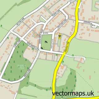
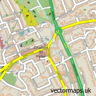
This Seer Green street map is a detailed vector street map covering a 750m x 750m area. Select a larger area to create and download your own vector street map of Seer Green.
The 750-metre map sample for Seer Green covers 408 mapped buildings and approximately 13.3 km of road detail, of which 28 named roads are named. The immediate area includes 5 pubs and 5 MOT stations within 2 miles. The wider area around Seer Green features 5 food and drink venues. To create a larger or custom map of Seer Green, the map builder lets you define your own coverage area and download editable SVG, PDF and PNG files.
Create a larger editable map of Seer Green
Choose any area you need and generate a high-quality vector map instantly. Perfect for print, planning, design, business and personal use.

This Seer Green street map in Buckinghamshire is available as downloadable SVG, PDF and PNG map files, or as a printed map for planning, business, display, education, local information and design work. You can also create a larger custom map area using the map selector.
What this Seer Green map sample shows
Seer Green lies within Seer Green Cp parish, part of Seer Green ward in the Buckinghamshire local authority area. The postcode geography for this area includes the HP postcode area, the HP9 postcode district and the HP9 2 postcode sector. Residents fall under the Nhs Buckinghamshire, Oxfordshire And Berkshire West Integrated Care Board for NHS services.
Local features near Seer Green
Within 2 milesAmenities and services in and around Seer Green.
Administrative and postcode information for Seer Green
Seer Green lies within Seer Green Cp parish, part of Seer Green ward in the Buckinghamshire local authority area. The postcode geography for this area includes the HP postcode area, the HP9 postcode district and the HP9 2 postcode sector. Residents fall under the Nhs Buckinghamshire, Oxfordshire And Berkshire West Integrated Care Board for NHS services.
Nearby street map samples around Seer Green

More street maps in Buckinghamshire
750 metre map area coverage
Boundary, postcode and point of interest information for the 750m x 750m rectangle centred on this sample map.
Boundaries containing map centre
Constituency: Chesham and Amersham Co Const
District: Buckinghamshire
Icb: NHS Thames Valley ICB
Parish: Seer Green CP
Police Force: thames valley
Postcode District: HP9
Postcode Sector: HP9 2
Ward: Chalfont St. Giles & Little Chalfont Ward
Nearby boundaries intersecting sample
Constituency: Beaconsfield Co Const
Parish: Beaconsfield CP
Ward: Beaconsfield Ward
Postcode coverage
POI category counts
Pub: 5
Building Contractor: 2
Building Supply Store: 2
Business Management Services: 2
Contractor: 2
Used Car Dealer: 2
Anglican Church: 1
Arts And Crafts: 1
Atms: 1
Auto Body Shop: 1
Sample points of interest
- Holy Trinity Church
- SurpriseBox
- PayPoint
- Mark 1 Motors
- Seer Green Baptist Church
- Seereen UK
- Halpin Homes
- Q-Matic
- Concepts Garden Services
- Leaf
- Creative Custard Ltd.
- My Fathers Business Ltd.
Create a larger editable map of Seer Green
This sample shows only a 750 metre area. To create a larger map of Seer Green, use our map builder to choose your own coverage area, add titles and download editable SVG, PDF and PNG files.
Create a custom map of Seer Green