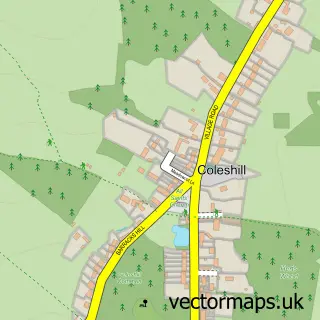
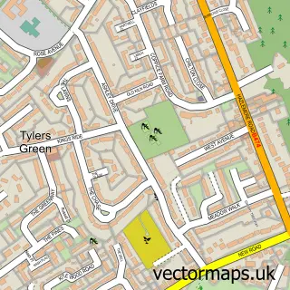
This Winchmore Hill street map is a detailed vector street map covering a 750m x 750m area. Select a larger area to create and download your own vector street map of Winchmore Hill.
The 750-metre map sample for Winchmore Hill covers 185 mapped buildings and approximately 11.3 km of road detail, of which 8 named roads are named. The immediate area includes 1 pub and 1 MOT station, with 4 within 2 miles. The wider area around Winchmore Hill features 1 food and drink venue. To create a larger or custom map of Winchmore Hill, the map builder lets you define your own coverage area and download editable SVG, PDF and PNG files.
Create a larger editable map of Winchmore Hill
Choose any area you need and generate a high-quality vector map instantly. Perfect for print, planning, design, business and personal use.

This Winchmore Hill street map in Buckinghamshire is available as downloadable SVG, PDF and PNG map files, or as a printed map for planning, business, display, education, local information and design work. You can also create a larger custom map area using the map selector.
What this Winchmore Hill map sample shows
Winchmore Hill lies within Penn Cp parish, part of Penn And Coleshill ward in the Buckinghamshire local authority area. The postcode geography for this area includes the HP postcode area, the HP7 postcode district and the HP7 0 postcode sector. Residents fall under the Nhs Buckinghamshire, Oxfordshire And Berkshire West Integrated Care Board for NHS services.
Local features near Winchmore Hill
Within 2 milesAmenities and services in and around Winchmore Hill.
Administrative and postcode information for Winchmore Hill
The local authority covering Winchmore Hill is Buckinghamshire, within the county of Buckinghamshire. The settlement lies within Penn And Coleshill ward and Penn Cp civil parish. The HP7 postcode district and HP7 0 postcode sector serve the immediate area. NHS provision in the area is delivered through Buckinghamshire Healthcare Nhs Trust.
Nearby street map samples around Winchmore Hill

More street maps in Buckinghamshire
750 metre map area coverage
Boundary, postcode and point of interest information for the 750m x 750m rectangle centred on this sample map.
Boundaries containing map centre
Constituency: Chesham and Amersham Co Const
District: Buckinghamshire
Icb: NHS Thames Valley ICB
Parish: Penn CP
Police Force: thames valley
Postcode District: HP7
Postcode Sector: HP7 0
Ward: Penn, Tylers Green & Loudwater Ward
Nearby boundaries intersecting sample
No additional intersecting boundaries found.
Postcode coverage
POI category counts
Community Center: 2
Art Restoration Service: 1
Automotive Services And Repair: 1
Bridal Shop: 1
Business Consulting: 1
Community Services Non Profits: 1
Construction Services: 1
Convenience Store: 1
Gastropub: 1
Marketing Agency: 1
Sample points of interest
- Enamel Restoration
- Securon
- Only Weddings
- Corporate Drama
- Winchmore Hill Memorial Hall
- Winchmore Hill Village Hall - Buckinghamshire
- Winchmore Hill Residents Association
- TAC Construction Ltd
- Ye Olde Village Shop
- The Plough, Amersham
- Phast Media Limited
- Longcroft Luxury Cat Hotel Winchmore Hill, Buckinghamshire
Create a larger editable map of Winchmore Hill
This sample shows only a 750 metre area. To create a larger map of Winchmore Hill, use our map builder to choose your own coverage area, add titles and download editable SVG, PDF and PNG files.
Create a custom map of Winchmore Hill