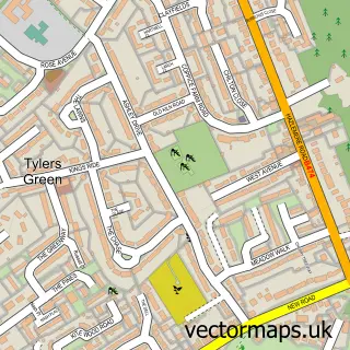
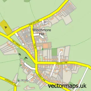
This Penn street map is a detailed vector street map covering a 750m x 750m area. Select a larger area to create and download your own vector street map of Penn.
The 750-metre map sample for Penn covers 170 mapped buildings and approximately 7.4 km of road detail, of which 6 named roads are named. The immediate area includes 1 school, 2 GP surgeries within 2 miles, 1 pub and 10 MOT stations within 2 miles. The wider area around Penn features 1 tourism point of interest and 1 food and drink venue. To create a larger or custom map of Penn, the map builder lets you define your own coverage area and download editable SVG, PDF and PNG files.
Create a larger editable map of Penn
Choose any area you need and generate a high-quality vector map instantly. Perfect for print, planning, design, business and personal use.

This Penn street map in Buckinghamshire is available as downloadable SVG, PDF and PNG map files, or as a printed map for planning, business, display, education, local information and design work. You can also create a larger custom map area using the map selector.
What this Penn map sample shows
Penn lies within Penn Cp parish, part of Penn And Coleshill ward in the Buckinghamshire local authority area. The postcode geography for this area includes the HP postcode area, the HP10 postcode district and the HP10 8 postcode sector. Residents fall under the Nhs Buckinghamshire, Oxfordshire And Berkshire West Integrated Care Board for NHS services.
Local features near Penn
Within 2 milesAmenities and services in and around Penn.
Administrative and postcode information for Penn
Penn lies within Penn Cp parish, part of Penn And Coleshill ward in the Buckinghamshire local authority area. The postcode geography for this area includes the HP postcode area, the HP10 postcode district and the HP10 8 postcode sector. Residents fall under the Nhs Buckinghamshire, Oxfordshire And Berkshire West Integrated Care Board for NHS services.
Nearby street map samples around Penn

More street maps in Buckinghamshire
750 metre map area coverage
Boundary, postcode and point of interest information for the 750m x 750m rectangle centred on this sample map.
Boundaries containing map centre
Constituency: Chesham and Amersham Co Const
District: Buckinghamshire
Icb: NHS Thames Valley ICB
Parish: Penn CP
Police Force: thames valley
Postcode District: HP10
Postcode Sector: HP10 8
Ward: Penn, Tylers Green & Loudwater Ward
Nearby boundaries intersecting sample
Constituency: Wycombe Co Const
Parish: Chepping Wycombe CP
Postcode coverage
POI category counts
Convenience Store: 3
Building Contractor: 2
Financial Advising: 2
Retail: 2
Advertising Agency: 1
Assisted Living Facility: 1
Attractions And Activities: 1
Building Supply Store: 1
Delicatessen: 1
Elementary School: 1
Sample points of interest
- The Haystack Group
- Alde House
- Penn Common
- Nicholas King Homes PLC/ NKhomes
- Nicholas King Homes Pvt. Ltd. Company
- DJM Garden Landscapes
- Premier Chattha's
- Village Shop
- Village Shop
- JJ's Delicatessen
- Tylers Green First School
- Employment Law in Action
Create a larger editable map of Penn
This sample shows only a 750 metre area. To create a larger map of Penn, use our map builder to choose your own coverage area, add titles and download editable SVG, PDF and PNG files.
Create a custom map of Penn