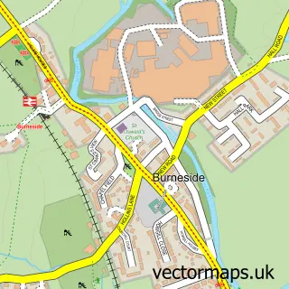
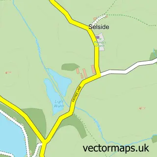
This Staveley street map is a detailed vector street map covering a 750m x 750m area. Select a larger area to create and download your own vector street map of Staveley.
The 750-metre map sample for Staveley covers 252 mapped buildings and approximately 14.4 km of road detail, of which 22 named roads are named. The immediate area includes 2 schools, 1 railway station, 1 pub and 1 MOT station, with 2 within 2 miles. The wider area around Staveley features 3 tourism points of interest, 5 food and drink venues and 2 hotels. To create a larger or custom map of Staveley, the map builder lets you define your own coverage area and download editable SVG, PDF and PNG files.
Create a larger editable map of Staveley
Choose any area you need and generate a high-quality vector map instantly. Perfect for print, planning, design, business and personal use.

This Staveley street map in Cumbria is available as downloadable SVG, PDF and PNG map files, or as a printed map for planning, business, display, education, local information and design work. You can also create a larger custom map area using the map selector.
What this Staveley map sample shows
Staveley lies within Nether Staveley Cp parish, part of Kendal Rural ward in the Westmorland And Furness local authority area. The postcode geography for this area includes the LA postcode area, the LA8 postcode district and the LA8 9 postcode sector. Residents fall under the Nhs Lancashire And South Cumbria Integrated Care Board for NHS services.
Local features near Staveley
Within 2 milesAmenities and services in and around Staveley.
Administrative and postcode information for Staveley
Staveley lies within Nether Staveley Cp parish, part of Kendal Rural ward in the Westmorland And Furness local authority area. The postcode geography for this area includes the LA postcode area, the LA8 postcode district and the LA8 9 postcode sector. Residents fall under the Nhs Lancashire And South Cumbria Integrated Care Board for NHS services.
Nearby street map samples around Staveley

More street maps in Cumbria
750 metre map area coverage
Boundary, postcode and point of interest information for the 750m x 750m rectangle centred on this sample map.
Boundaries containing map centre
Constituency: Westmorland and Lonsdale Co Const
District: Westmorland and Furness
Icb: NHS Lancashire and South Cumbria ICB
Parish: Over Staveley CP
Police Force: cumbria
Postcode District: LA8
Postcode Sector: LA8 9
Ward: Upper Kent Ward
Nearby boundaries intersecting sample
Parish: Hugill CP, Nether Staveley CP
Postcode coverage
POI category counts
Advertising Agency: 3
Building Supply Store: 3
Cafe: 3
Church Cathedral: 3
Gym: 3
Shipping Center: 3
Brewery: 2
Business To Business: 2
Chocolatier: 2
Community Services Non Profits: 2
Sample points of interest
- Run and Rock Guiding
- Cactus Creative Limited
- Design Works
- Eclectic Creative
- Amanda Etherington
- St James
- Staveley Antiques
- Sapphire Motor Cycles
- Superlove Merino UK
- More? The Artisan Bakery
- Staveley Barbers
- Laura's Hair & Beauty Salon
Create a larger editable map of Staveley
This sample shows only a 750 metre area. To create a larger map of Staveley, use our map builder to choose your own coverage area, add titles and download editable SVG, PDF and PNG files.
Create a custom map of Staveley