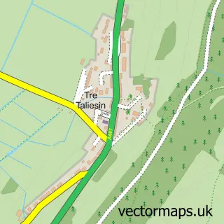
This Tal-y-bont street map is a detailed vector street map covering a 750m x 750m area. Select a larger area to create and download your own vector street map of Tal-y-bont.
The 750-metre map sample for Tal-y-bont covers 131 mapped buildings and approximately 12.0 km of road detail, of which 6 named roads are named. The immediate area includes 1 school, 3 pubs and 1 MOT station. The wider area around Tal-y-bont features 1 tourism point of interest, 4 food and drink venues and 1 hotel. To create a larger or custom map of Tal-y-bont, the map builder lets you define your own coverage area and download editable SVG, PDF and PNG files.
Create a larger editable map of Tal-y-bont
Choose any area you need and generate a high-quality vector map instantly. Perfect for print, planning, design, business and personal use.

This Tal-y-bont street map in Dyfed is available as downloadable SVG, PDF and PNG map files, or as a printed map for planning, business, display, education, local information and design work. You can also create a larger custom map area using the map selector.
What this Tal-y-bont map sample shows
Tal-y-bont lies within Ceulanamaesmawr Community parish, part of Ceulanamaesmawr ward in the Sir Ceredigion - Ceredigion local authority area. The postcode geography for this area includes the SY postcode area, the SY24 postcode district and the SY24 5 postcode sector. Residents fall under the Hywel Dda University Health Board for NHS services.
Local features near Tal-y-bont
Within 2 milesAmenities and services in and around Tal-y-bont.
Administrative and postcode information for Tal-y-bont
The local authority covering Tal-y-bont is Sir Ceredigion - Ceredigion, within the county of Dyfed. The settlement lies within Ceulanamaesmawr ward and Ceulanamaesmawr Community civil parish. The SY24 postcode district and SY24 5 postcode sector serve the immediate area. NHS provision in the area is delivered through Hywel Dda University Health Board.
Nearby street map samples around Tal-y-bont


More street maps in Dyfed
750 metre map area coverage
Boundary, postcode and point of interest information for the 750m x 750m rectangle centred on this sample map.
Boundaries containing map centre
Constituency: Ceredigion Preseli Co Const
District: Sir Ceredigion - Ceredigion
Icb: Hywel Dda
Parish: Ceulanamaesmawr Community
Police Force: dyfed-powys
Postcode District: SY24
Postcode Sector: SY24 5
Nearby boundaries intersecting sample
No additional intersecting boundaries found.
Postcode coverage
POI category counts
Convenience Store: 3
Pub: 3
Automotive Repair: 1
Cafe: 1
Community Services Non Profits: 1
Environmental Conservation Organization: 1
Farm: 1
Hair Salon: 1
Hotel: 1
Irish Pub: 1
Sample points of interest
- Davmor Motor Company Limited
- Caffi Gruff
- Sioe Talybont, Ceredigion
- Premier
- SPAR
- Siop Talybont
- Ecology Matters
- Moelgolomen Farm
- Salon leri
- white lion hotel
- White Lion Hotel
- Talybont, Ceredigion
Create a larger editable map of Tal-y-bont
This sample shows only a 750 metre area. To create a larger map of Tal-y-bont, use our map builder to choose your own coverage area, add titles and download editable SVG, PDF and PNG files.
Create a custom map of Tal-y-bont