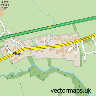
This Thorpe Thewles street map is a detailed vector street map covering a 750m x 750m area. Select a larger area to create and download your own vector street map of Thorpe Thewles.
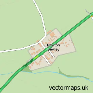
The 750-metre map sample for Thorpe Thewles covers 161 mapped buildings and approximately 12.8 km of road detail, of which 12 named roads are named. The immediate area includes 1 GP surgery within 2 miles, 2 pubs and 1 MOT station within 2 miles. The wider area around Thorpe Thewles features 1 tourism point of interest, 2 food and drink venues and 1 hotel. To create a larger or custom map of Thorpe Thewles, the map builder lets you define your own coverage area and download editable SVG, PDF and PNG files.
Create a larger editable map of Thorpe Thewles
Choose any area you need and generate a high-quality vector map instantly. Perfect for print, planning, design, business and personal use.

This Thorpe Thewles street map in Durham is available as downloadable SVG, PDF and PNG map files, or as a printed map for planning, business, display, education, local information and design work. You can also create a larger custom map area using the map selector.
What this Thorpe Thewles map sample shows
Thorpe Thewles lies within Grindon And Thorpe Thewles Cp parish, part of Northern Parishes ward in the Stockton-On-Tees (B) local authority area. The postcode geography for this area includes the TS postcode area, the TS21 postcode district and the TS21 3 postcode sector. Residents fall under the Nhs North East And North Cumbria Integrated Care Board for NHS services.
Local features near Thorpe Thewles
Within 2 milesAmenities and services in and around Thorpe Thewles.
Administrative and postcode information for Thorpe Thewles
The local authority covering Thorpe Thewles is Stockton-On-Tees (B), within the county of Durham. The settlement lies within Northern Parishes ward and Grindon And Thorpe Thewles Cp civil parish. The TS21 postcode district and TS21 3 postcode sector serve the immediate area. NHS provision in the area is delivered through North Tees And Hartlepool Nhs Foundation Trust.
Nearby street map samples around Thorpe Thewles

More street maps in Durham
750 metre map area coverage
Boundary, postcode and point of interest information for the 750m x 750m rectangle centred on this sample map.
Boundaries containing map centre
Constituency: Stockton North Co Const
District: Stockton-on-Tees (B)
Icb: NHS North East and North Cumbria ICB
Parish: Grindon and Thorpe Thewles CP
Police Force: cleveland
Postcode District: TS21
Postcode Sector: TS21 3
Ward: Northern Parishes Ward
Nearby boundaries intersecting sample
Constituency: Stockton West Co Const
Parish: Carlton CP
Postcode coverage
POI category counts
Church Cathedral: 2
Gym: 2
Pub: 2
Anglican Church: 1
Beauty Salon: 1
Bicycle Shop: 1
Bridal Shop: 1
Gastropub: 1
Hotel: 1
Park: 1
Sample points of interest
- St James Church, Thorpe Thewles
- Tips To Toes At Pinders
- Thorpe Thewles Cycles
- In Vogue Wedding Cars
- Holy Trinity Church, Thorpe Thewles
- Saint James Church
- Hamilton Russell
- Hideaway Golf
- Xercise4Less
- The Hideaway - Thorpe Thewles
- Wynyard Woodland Park
- Ellehcim Pace Your Pooch
Create a larger editable map of Thorpe Thewles
This sample shows only a 750 metre area. To create a larger map of Thorpe Thewles, use our map builder to choose your own coverage area, add titles and download editable SVG, PDF and PNG files.
Create a custom map of Thorpe Thewles