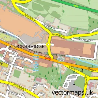
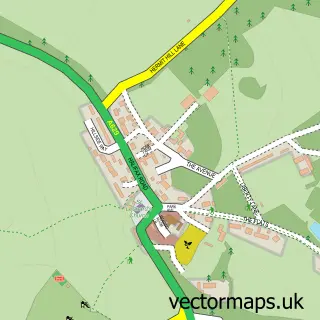
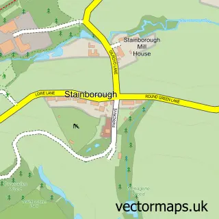
This Thurgoland street map is a detailed vector street map covering a 750m x 750m area. Select a larger area to create and download your own vector street map of Thurgoland.
The 750-metre map sample for Thurgoland covers 259 mapped buildings and approximately 9.6 km of road detail, of which 18 named roads are named. The immediate area includes 1 school, 1 GP surgery within 2 miles, 3 pubs and 1 MOT station, with 4 within 2 miles. The wider area around Thurgoland features 1 tourism point of interest and 3 food and drink venues. To create a larger or custom map of Thurgoland, the map builder lets you define your own coverage area and download editable SVG, PDF and PNG files.
Create a larger editable map of Thurgoland
Choose any area you need and generate a high-quality vector map instantly. Perfect for print, planning, design, business and personal use.

This Thurgoland street map in South Yorkshire is available as downloadable SVG, PDF and PNG map files, or as a printed map for planning, business, display, education, local information and design work. You can also create a larger custom map area using the map selector.
What this Thurgoland map sample shows
Thurgoland lies within Thurgoland Cp parish, part of Penistone East ward in the Barnsley District (B) local authority area. The postcode geography for this area includes the S postcode area, the S35 postcode district and the S35 7 postcode sector. Residents fall under the Nhs South Yorkshire Integrated Care Board for NHS services.
Local features near Thurgoland
Within 2 milesAmenities and services in and around Thurgoland.
Administrative and postcode information for Thurgoland
The local authority covering Thurgoland is Barnsley District (B), within the county of South Yorkshire. The settlement lies within Penistone East ward and Thurgoland Cp civil parish. The S35 postcode district and S35 7 postcode sector serve the immediate area. NHS provision in the area is delivered through Barnsley Hospital Nhs Foundation Trust.
Nearby street map samples around Thurgoland

More street maps in South Yorkshire
750 metre map area coverage
Boundary, postcode and point of interest information for the 750m x 750m rectangle centred on this sample map.
Boundaries containing map centre
Constituency: Penistone and Stocksbridge Co Const
District: Barnsley District (B)
Icb: NHS South Yorkshire ICB
Parish: Thurgoland CP
Police Force: south yorkshire
Postcode District: S35
Postcode Sector: S35 7
Ward: Penistone East Ward
Nearby boundaries intersecting sample
No additional intersecting boundaries found.
Postcode coverage
POI category counts
Pub: 3
Automotive: 2
Arts And Entertainment: 1
Automotive Repair: 1
Beauty Product Supplier: 1
Business Management Services: 1
Church Cathedral: 1
Community Center: 1
Doctor: 1
Elementary School: 1
Sample points of interest
- Horse & Jockey
- Elite Autos
- J B Burkinshaw & Son
- J B Burkinshaw & Son
- Cheryl Clarke
- Cuba Consultants Ltd.
- Holy Trinity Church
- Thurgoland Community Hall
- Penistone Group Practice - Thurgoland Branch
- Thurgoland C of E Primary School
- Cellar 41
- Harmony Hair & Beauty
Create a larger editable map of Thurgoland
This sample shows only a 750 metre area. To create a larger map of Thurgoland, use our map builder to choose your own coverage area, add titles and download editable SVG, PDF and PNG files.
Create a custom map of Thurgoland