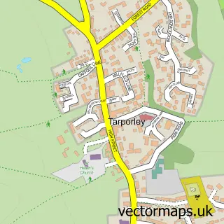
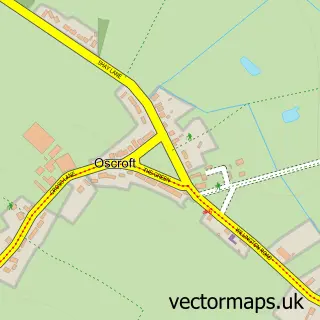
This Utkinton street map is a detailed vector street map covering a 750m x 750m area. Select a larger area to create and download your own vector street map of Utkinton.
The 750-metre map sample for Utkinton covers 135 mapped buildings and approximately 6.7 km of road detail, of which 8 named roads are named. The immediate area includes 2 GP surgeries within 2 miles and 2 MOT stations within 2 miles. The wider area around Utkinton features 1 food and drink venue. To create a larger or custom map of Utkinton, the map builder lets you define your own coverage area and download editable SVG, PDF and PNG files.
Create a larger editable map of Utkinton
Choose any area you need and generate a high-quality vector map instantly. Perfect for print, planning, design, business and personal use.

This Utkinton street map in Cheshire is available as downloadable SVG, PDF and PNG map files, or as a printed map for planning, business, display, education, local information and design work. You can also create a larger custom map area using the map selector.
What this Utkinton map sample shows
Utkinton lies within Utkinton And Cotebrook Cp parish, part of Tarporley ward in the Cheshire West And Chester (B) local authority area. The postcode geography for this area includes the CW postcode area, the CW6 postcode district and the CW6 0 postcode sector. Residents fall under the Nhs Cheshire And Merseyside Integrated Care Board for NHS services.
Local features near Utkinton
Within 2 milesAmenities and services in and around Utkinton.
Administrative and postcode information for Utkinton
Utkinton lies within Utkinton And Cotebrook Cp parish, part of Tarporley ward in the Cheshire West And Chester (B) local authority area. The postcode geography for this area includes the CW postcode area, the CW6 postcode district and the CW6 0 postcode sector. Residents fall under the Nhs Cheshire And Merseyside Integrated Care Board for NHS services.
Nearby street map samples around Utkinton

More street maps in Cheshire
750 metre map area coverage
Boundary, postcode and point of interest information for the 750m x 750m rectangle centred on this sample map.
Boundaries containing map centre
Constituency: Chester South and Eddisbury Co Const
District: Cheshire West and Chester (B)
Icb: NHS Cheshire and Merseyside ICB
Parish: Utkinton and Cotebrook CP
Police Force: cheshire
Postcode District: CW6
Postcode Sector: CW6 0
Ward: Tarporley Ward
Nearby boundaries intersecting sample
Parish: Willington CP
Ward: Tarvin & Kelsall Ward
Postcode coverage
POI category counts
Shipping Center: 2
Auto Detailing: 1
Automotive: 1
Automotive Dealer: 1
Beauty Salon: 1
Bicycle Shop: 1
Building Supply Store: 1
Business To Business: 1
Chiropractor: 1
Coffee Shop: 1
Sample points of interest
- Shop 'N' Wash
- Miglia Automotive
- Factory Campers
- Perfectly Polished by Sam
- Kelsall Cycles
- Green Spaces Landscapes
- Aquapharm Chemical
- Kairos Chiropractic
- Coffee House at Rosefarm
- Utkinton Village Hall
- Utkinton WI
- Utkinton St Paul's C of E Primary School
Create a larger editable map of Utkinton
This sample shows only a 750 metre area. To create a larger map of Utkinton, use our map builder to choose your own coverage area, add titles and download editable SVG, PDF and PNG files.
Create a custom map of Utkinton