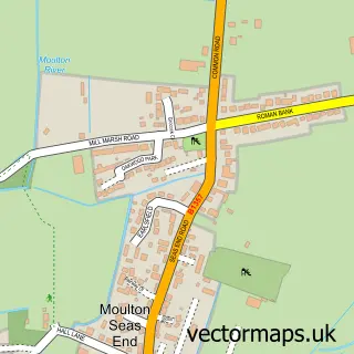
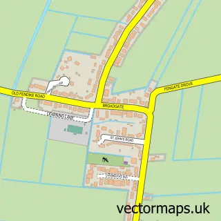
This Weston street map is a detailed vector street map covering a 750m x 750m area. Select a larger area to create and download your own vector street map of Weston.
The 750-metre map sample for Weston covers 413 mapped buildings and approximately 13.0 km of road detail, of which 17 named roads are named. The immediate area includes 1 school, 1 GP surgery within 2 miles, 2 pubs and 2 MOT stations within 2 miles. The wider area around Weston features 1 tourism point of interest and 2 food and drink venues. To create a larger or custom map of Weston, the map builder lets you define your own coverage area and download editable SVG, PDF and PNG files.
Create a larger editable map of Weston
Choose any area you need and generate a high-quality vector map instantly. Perfect for print, planning, design, business and personal use.

This Weston street map in Lincolnshire is available as downloadable SVG, PDF and PNG map files, or as a printed map for planning, business, display, education, local information and design work. You can also create a larger custom map area using the map selector.
What this Weston map sample shows
Weston lies within Weston Cp parish, part of Moulton, Weston And Cowbit ward in the South Holland District local authority area. The postcode geography for this area includes the PE postcode area, the PE12 postcode district and the PE12 6 postcode sector. Residents fall under the Nhs Lincolnshire Integrated Care Board for NHS services.
Local features near Weston
Within 2 milesAmenities and services in and around Weston.
Administrative and postcode information for Weston
The local authority covering Weston is South Holland District, within the county of Lincolnshire. The settlement lies within Moulton, Weston And Cowbit ward and Weston Cp civil parish. The PE12 postcode district and PE12 6 postcode sector serve the immediate area. NHS provision in the area is delivered through United Lincolnshire Hospitals Nhs Trust.
Nearby street map samples around Weston


More street maps in Lincolnshire
750 metre map area coverage
Boundary, postcode and point of interest information for the 750m x 750m rectangle centred on this sample map.
Boundaries containing map centre
Constituency: South Holland and The Deepings Co Const
County: Lincolnshire County
District: South Holland District
Icb: NHS Lincolnshire ICB
Parish: Weston CP
Police Force: lincolnshire
Postcode District: PE12
Postcode Sector: PE12 6
Ward: Moulton, Weston and Cowbit Ward
Nearby boundaries intersecting sample
No additional intersecting boundaries found.
Postcode coverage
POI category counts
Post Office: 2
Pub: 2
Web Designer: 2
Anglican Church: 1
Art School: 1
Clothing Store: 1
Convenience Store: 1
Gym: 1
Home Developer: 1
Korean Grocery Store: 1
Sample points of interest
- St Mary the Virgin, Weston
- Apple Tree House Studio
- Bonmarché
- Budgens Weston (Spalding)
- Weston Village Hall - Lincolnshire
- Persimmon Homes The Maples
- Post Office-Weston
- Claire Lunn Therapies
- Weston Playing Field
- Post Office
- Weston Village Store
- Chequers of Weston
Create a larger editable map of Weston
This sample shows only a 750 metre area. To create a larger map of Weston, use our map builder to choose your own coverage area, add titles and download editable SVG, PDF and PNG files.
Create a custom map of Weston