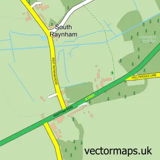
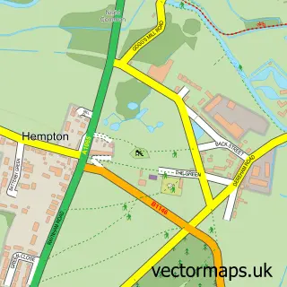
This Whissonsett street map is a detailed vector street map covering a 750m x 750m area. Select a larger area to create and download your own vector street map of Whissonsett.
The 750-metre map sample for Whissonsett covers 229 mapped buildings and approximately 13.3 km of road detail, of which 16 named roads are named. The wider area around Whissonsett features 1 campsite within 2 miles. To create a larger or custom map of Whissonsett, the map builder lets you define your own coverage area and download editable SVG, PDF and PNG files.
Create a larger editable map of Whissonsett
Choose any area you need and generate a high-quality vector map instantly. Perfect for print, planning, design, business and personal use.

This Whissonsett street map in Norfolk is available as downloadable SVG, PDF and PNG map files, or as a printed map for planning, business, display, education, local information and design work. You can also create a larger custom map area using the map selector.
What this Whissonsett map sample shows
Whissonsett lies within Whissonsett Cp parish, part of Hermitage ward in the Breckland District local authority area. The postcode geography for this area includes the NR postcode area, the NR20 postcode district and the NR20 5 postcode sector. Residents fall under the Nhs Norfolk And Waveney Integrated Care Board for NHS services.
Local features near Whissonsett
Within 2 milesAmenities and services in and around Whissonsett.
Administrative and postcode information for Whissonsett
Whissonsett lies within Whissonsett Cp parish, part of Hermitage ward in the Breckland District local authority area. The postcode geography for this area includes the NR postcode area, the NR20 postcode district and the NR20 5 postcode sector. Residents fall under the Nhs Norfolk And Waveney Integrated Care Board for NHS services.
Nearby street map samples around Whissonsett

More street maps in Norfolk
750 metre map area coverage
Boundary, postcode and point of interest information for the 750m x 750m rectangle centred on this sample map.
Boundaries containing map centre
Constituency: Mid Norfolk Co Const
County: Norfolk County
District: Breckland District
Icb: NHS Norfolk and Waveney ICB
Parish: Whissonsett CP
Police Force: norfolk
Postcode District: NR20
Postcode Sector: NR20 5
Ward: Hermitage Ward
Nearby boundaries intersecting sample
No additional intersecting boundaries found.
Postcode coverage
POI category counts
Korean Grocery Store: 2
Anglican Church: 1
Art School: 1
Community Center: 1
Cottage: 1
Interior Design: 1
Office Equipment: 1
Preschool: 1
Sporting Goods: 1
Web Designer: 1
Sample points of interest
- Whissonsett Church
- Art Classes and Life Drawing
- Whissonsett Village Hall
- Paston Cottage Bees
- Mason Decorators
- Post Office-Whissonsett
- Whissonsett Post Office
- Anglia Epos
- Beetley & District Pre School
- Tipi Hire
- Webmaker Ltd.
Create a larger editable map of Whissonsett
This sample shows only a 750 metre area. To create a larger map of Whissonsett, use our map builder to choose your own coverage area, add titles and download editable SVG, PDF and PNG files.
Create a custom map of Whissonsett