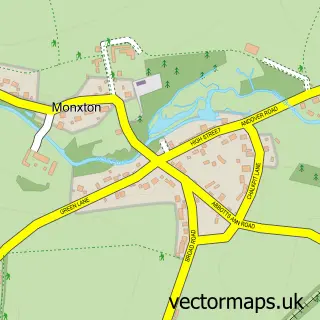
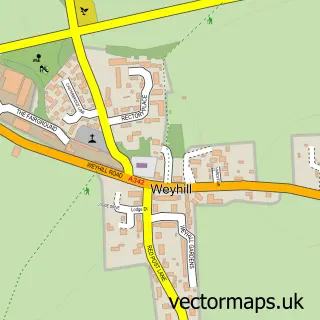
This Amport street map is a detailed vector street map covering a 750m x 750m area. Select a larger area to create and download your own vector street map of Amport.
The 750-metre map sample for Amport covers 68 mapped buildings and approximately 5.8 km of road detail, of which 3 named roads are named. The immediate area includes 1 school and 1 MOT station within 2 miles. The wider area around Amport features 2 tourism points of interest. To create a larger or custom map of Amport, the map builder lets you define your own coverage area and download editable SVG, PDF and PNG files.
Create a larger editable map of Amport
Choose any area you need and generate a high-quality vector map instantly. Perfect for print, planning, design, business and personal use.

This Amport street map in Hampshire is available as downloadable SVG, PDF and PNG map files, or as a printed map for planning, business, display, education, local information and design work. You can also create a larger custom map area using the map selector.
What this Amport map sample shows
Amport lies within Amport Cp parish, part of Anna ward in the Test Valley District local authority area. The postcode geography for this area includes the SP postcode area, the SP11 postcode district and the SP11 8 postcode sector. Residents fall under the Nhs Hampshire And Isle Of Wight Integrated Care Board for NHS services.
Local features near Amport
Within 2 milesAmenities and services in and around Amport.
Administrative and postcode information for Amport
Amport lies within Amport Cp parish, part of Anna ward in the Test Valley District local authority area. The postcode geography for this area includes the SP postcode area, the SP11 postcode district and the SP11 8 postcode sector. Residents fall under the Nhs Hampshire And Isle Of Wight Integrated Care Board for NHS services.
Nearby street map samples around Amport


More street maps in Hampshire
750 metre map area coverage
Boundary, postcode and point of interest information for the 750m x 750m rectangle centred on this sample map.
Boundaries containing map centre
Constituency: Romsey and Southampton North Co Const
County: Hampshire County
District: Test Valley District
Icb: NHS Hampshire and Isle of Wight ICB
Parish: Amport CP
Police Force: hampshire
Postcode District: SP11
Postcode Sector: SP11 8
Ward: Anna Ward
Nearby boundaries intersecting sample
No additional intersecting boundaries found.
Postcode coverage
POI category counts
Anglican Church: 1
Church Cathedral: 1
Elementary School: 1
Fishing Club: 1
Horse Riding: 1
Junk Removal And Hauling: 1
Kids Recreation And Party: 1
Landmark And Historical Building: 1
Landscaping: 1
Metal Fabricator: 1
Sample points of interest
- St Mary's, Amport
- St Mary's Church
- Amport C of E Primary School
- Amport Trout Fishery
- Amport Riding School
- Help Moving Office
- Amport Trout Fishery
- Amport House
- Greenflints Ltd.
- Boa Engineering Ltd.
- Museum of Army Chaplaincy
Create a larger editable map of Amport
This sample shows only a 750 metre area. To create a larger map of Amport, use our map builder to choose your own coverage area, add titles and download editable SVG, PDF and PNG files.
Create a custom map of Amport