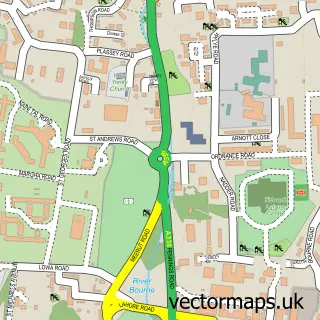
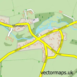
This Grateley street map is a detailed vector street map covering a 750m x 750m area. Select a larger area to create and download your own vector street map of Grateley.
The 750-metre map sample for Grateley covers 114 mapped buildings and approximately 9.5 km of road detail, of which 9 named roads are named. The immediate area includes 2 schools. To create a larger or custom map of Grateley, the map builder lets you define your own coverage area and download editable SVG, PDF and PNG files.
Create a larger editable map of Grateley
Choose any area you need and generate a high-quality vector map instantly. Perfect for print, planning, design, business and personal use.

This Grateley street map in Hampshire is available as downloadable SVG, PDF and PNG map files, or as a printed map for planning, business, display, education, local information and design work. You can also create a larger custom map area using the map selector.
What this Grateley map sample shows
Grateley lies within Grateley Cp parish, part of Anna ward in the Test Valley District local authority area. The postcode geography for this area includes the SP postcode area, the SP11 postcode district and the SP11 8 postcode sector. Residents fall under the Nhs Hampshire And Isle Of Wight Integrated Care Board for NHS services.
Local features near Grateley
Within 2 milesAmenities and services in and around Grateley.
Administrative and postcode information for Grateley
Grateley lies within Grateley Cp parish, part of Anna ward in the Test Valley District local authority area. The postcode geography for this area includes the SP postcode area, the SP11 postcode district and the SP11 8 postcode sector. Residents fall under the Nhs Hampshire And Isle Of Wight Integrated Care Board for NHS services.
Nearby street map samples around Grateley


More street maps in Hampshire
750 metre map area coverage
Boundary, postcode and point of interest information for the 750m x 750m rectangle centred on this sample map.
Boundaries containing map centre
Constituency: Romsey and Southampton North Co Const
County: Hampshire County
District: Test Valley District
Icb: NHS Hampshire and Isle of Wight ICB
Parish: Grateley CP
Police Force: hampshire
Postcode District: SP11
Postcode Sector: SP11 8
Ward: Anna Ward
Nearby boundaries intersecting sample
Parish: Quarley CP
Postcode Sector: SP11 7
Postcode coverage
POI category counts
Post Office: 2
Anglican Church: 1
Beauty Salon: 1
Carpenter: 1
Church Cathedral: 1
Desserts: 1
Education: 1
Elementary School: 1
Himalayan Nepalese Restaurant: 1
Retail: 1
Sample points of interest
- St Leonard's, Grateley
- Pomade Hair Design
- L H Carpentry Ltd
- St Leonard's Church
- SWEET TOOTH Waffles & Crepes
- Grateley House School
- Grateley Primary School
- Gurkha Baynjan - Plough Inn
- Grateley Post Office & Stores
- Post Office
- The Bike Shop
- Grateley House School
Create a larger editable map of Grateley
This sample shows only a 750 metre area. To create a larger map of Grateley, use our map builder to choose your own coverage area, add titles and download editable SVG, PDF and PNG files.
Create a custom map of Grateley