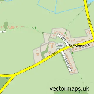
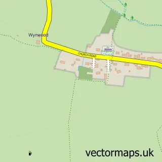
This Badwell Ash street map is a detailed vector street map covering a 750m x 750m area. Select a larger area to create and download your own vector street map of Badwell Ash.
The 750-metre map sample for Badwell Ash covers 323 mapped buildings and approximately 10.1 km of road detail, of which 13 named roads are named. The immediate area includes 1 pub and 1 MOT station within 2 miles. The wider area around Badwell Ash features 1 food and drink venue. To create a larger or custom map of Badwell Ash, the map builder lets you define your own coverage area and download editable SVG, PDF and PNG files.
Create a larger editable map of Badwell Ash
Choose any area you need and generate a high-quality vector map instantly. Perfect for print, planning, design, business and personal use.

This Badwell Ash street map in Suffolk is available as downloadable SVG, PDF and PNG map files, or as a printed map for planning, business, display, education, local information and design work. You can also create a larger custom map area using the map selector.
What this Badwell Ash map sample shows
Badwell Ash lies within Badwell Ash Cp parish, part of Walsham-Le-Willows ward in the Mid Suffolk District local authority area. The postcode geography for this area includes the IP postcode area, the IP31 postcode district and the IP31 3 postcode sector. Residents fall under the Nhs Suffolk And North East Essex Integrated Care Board for NHS services.
Local features near Badwell Ash
Within 2 milesAmenities and services in and around Badwell Ash.
Administrative and postcode information for Badwell Ash
The local authority covering Badwell Ash is Mid Suffolk District, within the county of Suffolk. The settlement lies within Walsham-Le-Willows ward and Badwell Ash Cp civil parish. The IP31 postcode district and IP31 3 postcode sector serve the immediate area. NHS provision in the area is delivered through West Suffolk Nhs Foundation Trust.
Nearby street map samples around Badwell Ash

More street maps in Suffolk
750 metre map area coverage
Boundary, postcode and point of interest information for the 750m x 750m rectangle centred on this sample map.
Boundaries containing map centre
Constituency: Waveney Valley Co Const
County: Suffolk County
District: Mid Suffolk District
Icb: NHS Essex ICB
Parish: Badwell Ash CP
Police Force: suffolk
Postcode District: IP31
Postcode Sector: IP31 3
Ward: Walsham-le-Willows Ward
Nearby boundaries intersecting sample
Parish: Langham CP
Postcode coverage
POI category counts
Convenience Store: 2
Anglican Church: 1
Community Center: 1
Event Photography: 1
Fish And Chips Restaurant: 1
Grocery Store: 1
Home Goods Store: 1
Lodge: 1
Online Shop: 1
Pest Control Service: 1
Sample points of interest
- Badwell Ash, St Mary
- Badwell Ash Village Hall
- Budgens BUDGENS - BADWELL ASH
- SPAR
- Tom Kellett Wedding Videography
- Rumbles Fish Bar and Takeaway
- The Blue Stall
- Architectural Textiles
- Badwell Ash Holiday Lodges
- Best Pest Solutions
- Best Pest Solutions Norfolk
- Post Office
Create a larger editable map of Badwell Ash
This sample shows only a 750 metre area. To create a larger map of Badwell Ash, use our map builder to choose your own coverage area, add titles and download editable SVG, PDF and PNG files.
Create a custom map of Badwell Ash