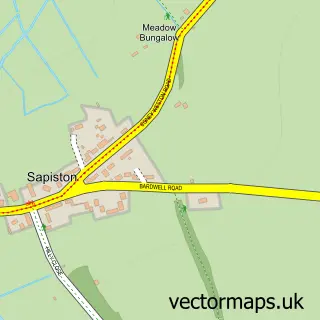
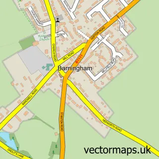
This Bardwell street map is a detailed vector street map covering a 750m x 750m area. Select a larger area to create and download your own vector street map of Bardwell.
The 750-metre map sample for Bardwell covers 220 mapped buildings and approximately 12.2 km of road detail, of which 12 named roads are named. The immediate area includes 1 school, 2 GP surgeries within 2 miles, 1 pub and 2 MOT stations within 2 miles. The wider area around Bardwell features 1 food and drink venue and 1 campsite within 2 miles. To create a larger or custom map of Bardwell, the map builder lets you define your own coverage area and download editable SVG, PDF and PNG files.
Create a larger editable map of Bardwell
Choose any area you need and generate a high-quality vector map instantly. Perfect for print, planning, design, business and personal use.

This Bardwell street map in Suffolk is available as downloadable SVG, PDF and PNG map files, or as a printed map for planning, business, display, education, local information and design work. You can also create a larger custom map area using the map selector.
What this Bardwell map sample shows
Bardwell lies within Bardwell Cp parish, part of Bardwell ward in the West Suffolk District local authority area. The postcode geography for this area includes the IP postcode area, the IP31 postcode district and the IP31 1 postcode sector. Residents fall under the Nhs Suffolk And North East Essex Integrated Care Board for NHS services.
Local features near Bardwell
Within 2 milesAmenities and services in and around Bardwell.
Administrative and postcode information for Bardwell
The local authority covering Bardwell is West Suffolk District, within the county of Suffolk. The settlement lies within Bardwell ward and Bardwell Cp civil parish. The IP31 postcode district and IP31 1 postcode sector serve the immediate area. NHS provision in the area is delivered through West Suffolk Nhs Foundation Trust.
Nearby street map samples around Bardwell


More street maps in Suffolk
750 metre map area coverage
Boundary, postcode and point of interest information for the 750m x 750m rectangle centred on this sample map.
Boundaries containing map centre
Constituency: Bury St. Edmunds and Stowmarket Co Const
County: Suffolk County
District: West Suffolk District
Icb: NHS Essex ICB
Parish: Bardwell CP
Police Force: suffolk
Postcode District: IP31
Postcode Sector: IP31 1
Ward: Bardwell Ward
Nearby boundaries intersecting sample
No additional intersecting boundaries found.
Postcode coverage
POI category counts
Anglican Church: 2
Arts And Entertainment: 1
Automotive Repair: 1
B2b Sporting And Recreation Goods: 1
Building Supply Store: 1
Business: 1
Childrens Clothing Store: 1
Cupcake Shop: 1
Dog Walkers: 1
Elementary School: 1
Sample points of interest
- Bardwell Messy Church
- Bardwell, St Peter & St Paul
- Bardwell
- Inter UK Trailers
- Pen-Y-Coed Petanque
- S J Nice
- Freedom Couriers
- Turn of The Century Corsets
- Boutique Baking
- Jan's Dog Walking
- Bardwell CEVC Primary School
- Bardwell Windmill
Create a larger editable map of Bardwell
This sample shows only a 750 metre area. To create a larger map of Bardwell, use our map builder to choose your own coverage area, add titles and download editable SVG, PDF and PNG files.
Create a custom map of Bardwell