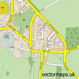
This Barrowden street map is a detailed vector street map covering a 750m x 750m area. Select a larger area to create and download your own vector street map of Barrowden.
The 750-metre map sample for Barrowden covers 227 mapped buildings and approximately 19.5 km of road detail, of which 18 named roads are named. The immediate area includes 1 pub and 2 MOT stations within 2 miles. The wider area around Barrowden features 3 food and drink venues. To create a larger or custom map of Barrowden, the map builder lets you define your own coverage area and download editable SVG, PDF and PNG files.
Create a larger editable map of Barrowden
Choose any area you need and generate a high-quality vector map instantly. Perfect for print, planning, design, business and personal use.

This Barrowden street map in Rutland is available as downloadable SVG, PDF and PNG map files, or as a printed map for planning, business, display, education, local information and design work. You can also create a larger custom map area using the map selector.
What this Barrowden map sample shows
Barrowden lies within Barrowden Cp parish, part of Ketton ward in the Rutland local authority area. The postcode geography for this area includes the LE postcode area, the LE15 postcode district and the LE15 8 postcode sector. Residents fall under the Nhs Leicester, Leicestershire And Rutland Integrated Care Board for NHS services.
Local features near Barrowden
Within 2 milesAmenities and services in and around Barrowden.
Administrative and postcode information for Barrowden
Barrowden lies within Barrowden Cp parish, part of Ketton ward in the Rutland local authority area. The postcode geography for this area includes the LE postcode area, the LE15 postcode district and the LE15 8 postcode sector. Residents fall under the Nhs Leicester, Leicestershire And Rutland Integrated Care Board for NHS services.
Nearby street map samples around Barrowden

More street maps in Rutland
750 metre map area coverage
Boundary, postcode and point of interest information for the 750m x 750m rectangle centred on this sample map.
Boundaries containing map centre
Constituency: Rutland and Stamford Co Const
District: Rutland
Icb: NHS Leicester Leicestershire and Rutland ICB
Parish: Barrowden CP
Police Force: leicestershire
Postcode District: LE15
Postcode Sector: LE15 8
Ward: Ketton Ward
Nearby boundaries intersecting sample
Constituency: Corby and East Northamptonshire Co Const
District: North Northamptonshire
Icb: NHS Northamptonshire ICB
Parish: Wakerley CP
Police Force: northamptonshire
Ward: Oundle Ward
Postcode coverage
POI category counts
Restaurant: 2
Anglican Church: 1
Bookstore: 1
Church Cathedral: 1
Contractor: 1
Convenience Store: 1
Cricket Ground: 1
Doctor: 1
Freight And Cargo Service: 1
Pub: 1
Sample points of interest
- St Peter's Barrowden
- The Homeopathic Book Company
- St Peters Church, Barrowden
- Rutland Hedging
- Barrowden and Wakerley Community Shop
- Wakerley and Barrowden Cricket Club
- Barrowden Surgery
- Pridmores Haulage
- Exeter Arms
- Exeter Arms
- Exeter Arms Barrowden
Create a larger editable map of Barrowden
This sample shows only a 750 metre area. To create a larger map of Barrowden, use our map builder to choose your own coverage area, add titles and download editable SVG, PDF and PNG files.
Create a custom map of Barrowden