Vector Maps logo
Home Why it works Popular maps Districts Samples Customizer Create Your Map
VectorMaps.uk
Home Popular maps Districts Samples Customizer Create Your Map Privacy Disclaimer
Home / UK Maps / Inverness / Beauly Map

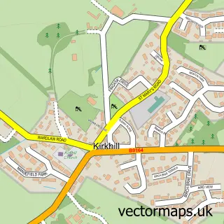
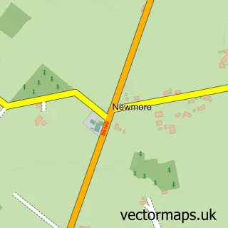
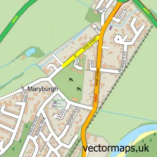
This Beauly street map is a detailed vector street map covering a 750m x 750m area. Select a larger area to create and download your own vector street map of Beauly.

Beauly is a town in Inverness, in the Highlands And Islands of Scotland. Historically, the area formed part of Inverness-Shire. The settlement falls within the Ross, Skye And Lochaber parliamentary constituency. It is served by the IV4 postcode district,

The 750-metre map sample for Beauly covers 127 mapped buildings and approximately 11.7 km of road detail, of which 23 named roads are named. The immediate area includes 2 GP surgeries and 1 MOT station, with 3 within 2 miles. The wider area around Beauly features 2 tourism points of interest, 3 food and drink venues and 4 hotels. To create a larger or custom map of Beauly, the map builder lets you define your own coverage area and download editable SVG, PDF and PNG files.

127Buildings
11.69 kmRoads
23Named roads
0Residents within 2 miles
Create your own

Create a larger editable map of Beauly

Choose any area you need and generate a high-quality vector map instantly. Perfect for print, planning, design, business and personal use.

Choose any location
Editable SVG files
Any size up to A0
PDF, PNG & more
Instant download
High quality guaranteed
Create My Custom Map
Secure, private & no credit card required
Beauly Vector Street Map
750m Sample
Beauly vector street map sample showing roads, buildings and local features in a 750 metre preview area
Buy Beauly Map Print from £12.95 Buy Beauly Digital Map from £6

This Beauly street map in Inverness is available as downloadable SVG, PDF and PNG map files, or as a printed map for planning, business, display, education, local information and design work. You can also create a larger custom map area using the map selector.

What this Beauly map sample shows

Beauly lies within Highland parish, part of Aird And Loch Ness ward in the Highland local authority area. The postcode geography for this area includes the IV postcode area, the IV4 postcode district and the IV4 7 postcode sector. Residents fall under the Highland for NHS services.

Local features near Beauly

Within 2 miles

Amenities and services in and around Beauly.

1 Campsites within 2 miles
2 GP surgeries 2 within 2 miles
1 MOT stations 3 within 2 miles
2 Tourism & leisure
3 Food & drink
4 Hotels
5 Healthcare POIs
1 Vehicle services

Counts are approximate and based on publicly available data.

Administrative and postcode information for Beauly

The local authority covering Beauly is Highland, within the county of Inverness. The settlement lies within Aird And Loch Ness ward and Highland civil parish. The IV4 postcode district and IV4 7 postcode sector serve the immediate area. NHS provision in the area is delivered through Highland.

Parish HIGHLAND
Ward Aird and Loch Ness
District / local authority Highland
County Inverness
Historic county Inverness-shire
Postcode district IV4
Postcode sector IV4 7
Parliamentary constituency Ross, Skye and Lochaber
Region Highlands and Islands
Country Scotland

Nearby street map samples around Beauly

Street map sample of Inverness, Inverness Inverness City - Inverness - 8.7 miles Street map sample of Kirkhill, Inverness Kirkhill Village - Inverness - 1.8 miles Street map sample of Kilmorack, Inverness Kilmorack Village - Inverness - 2.5 miles Street map sample of Inchmore, Inverness Inchmore Village - Inverness - 2.8 miles Street map sample of Kiltarlity, Inverness Kiltarlity Village - Inverness - 3.1 miles Street map sample of Mulbuie, Ross and Cromarty Mulbuie Village - Ross and Cromarty - 3.9 miles Street map sample of Marybank, Ross and Cromarty Marybank Village - Ross and Cromarty - 5.3 miles Street map sample of Conon Bridge, Ross and Cromarty Conon Bridge Village - Ross and Cromarty - 5.7 miles Street map sample of Tore, Ross and Cromarty Tore Village - Ross and Cromarty - 6.2 miles Street map sample of Maryburgh, Ross and Cromarty Maryburgh Village - Ross and Cromarty - 6.4 miles

More street maps in Inverness

Street map sample of Kirkhill, Inverness Kirkhill Village - 1.8 miles Street map sample of Kilmorack, Inverness Kilmorack Village - 2.5 miles Street map sample of Inchmore, Inverness Inchmore Village - 2.8 miles Street map sample of Kiltarlity, Inverness Kiltarlity Village - 3.1 miles Street map sample of Abriachan, Inverness Abriachan Village - 7.2 miles

750 metre map area coverage

Boundary, postcode and point of interest information for the 750m x 750m rectangle centred on this sample map.

Boundaries containing map centre

Constituency: Caithness, Sutherland and Easter Ross Co Const

District: Highland

Icb: Highland

Postcode District: IV4

Postcode Sector: IV4 7

Ward: Aird and Loch Ness Ward

Nearby boundaries intersecting sample

No additional intersecting boundaries found.

Postcode coverage

IV4 IV4 7

POI category counts

Bed And Breakfast: 4

Hair Salon: 4

Hotel: 4

Doctor: 3

Antique Store: 2

Bank Credit Union: 2

Catholic Church: 2

Chinese Restaurant: 2

Coffee Shop: 2

Convenience Store: 2

Sample points of interest

  • Iain Marr Antiques Antique Store
  • Marr Iain Antiques Antique Store
  • Aggregate Industries Appliance Manufacturer
  • Alder Arts Art Gallery
  • The Cooperative Food (BF) Beauly - Station Road (ERF) Atms
  • ChipsAway Inverness Automotive Repair
  • Harry Gow Bakery
  • Bank of Scotland Bank Credit Union
  • RBS Bank Credit Union
  • Royal Bank of Scotland Banks
  • Body Beautiful Beauty Salon
  • Archdale Bed And Breakfast

Create a larger editable map of Beauly

This sample shows only a 750 metre area. To create a larger map of Beauly, use our map builder to choose your own coverage area, add titles and download editable SVG, PDF and PNG files.

Create a custom map of Beauly

Phone 01751 473136 | Copyright Vectormaps.uk 2026

Samples Customizer Privacy Disclaimer
Beauly Vector Street Map
Beauly enlarged street map sample showing a 750 metre preview area