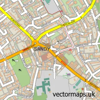
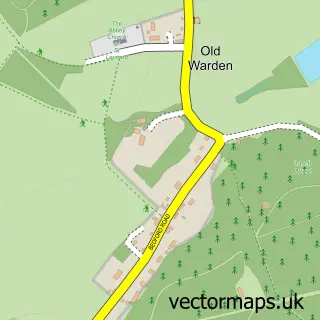
This Beeston street map is a detailed vector street map covering a 750m x 750m area. Select a larger area to create and download your own vector street map of Beeston.
The 750-metre map sample for Beeston covers 201 mapped buildings and approximately 8.7 km of road detail, of which 13 named roads are named. The immediate area includes 1 GP surgery within 2 miles and 7 MOT stations within 2 miles. The wider area around Beeston features 2 tourism points of interest. To create a larger or custom map of Beeston, the map builder lets you define your own coverage area and download editable SVG, PDF and PNG files.
Create a larger editable map of Beeston
Choose any area you need and generate a high-quality vector map instantly. Perfect for print, planning, design, business and personal use.

This Beeston street map in Bedfordshire is available as downloadable SVG, PDF and PNG map files, or as a printed map for planning, business, display, education, local information and design work. You can also create a larger custom map area using the map selector.
What this Beeston map sample shows
Beeston lies within Sandy Cp parish, part of Sandy ward in the Central Bedfordshire local authority area. The postcode geography for this area includes the SG postcode area, the SG19 postcode district and the SG19 1 postcode sector. Residents fall under the Nhs Bedfordshire, Luton And Milton Keynes Integrated Care Board for NHS services.
Local features near Beeston
Within 2 milesAmenities and services in and around Beeston.
Administrative and postcode information for Beeston
The local authority covering Beeston is Central Bedfordshire, within the county of Bedfordshire. The settlement lies within Sandy ward and Sandy Cp civil parish. The SG19 postcode district and SG19 1 postcode sector serve the immediate area. NHS provision in the area is delivered through Bedfordshire Hospitals Nhs Foundation Trust.
Nearby street map samples around Beeston

More street maps in Bedfordshire
750 metre map area coverage
Boundary, postcode and point of interest information for the 750m x 750m rectangle centred on this sample map.
Boundaries containing map centre
Constituency: North Bedfordshire Co Const
District: Central Bedfordshire
Icb: NHS Central East ICB
Parish: Sandy CP
Police Force: bedfordshire
Postcode District: SG19
Postcode Sector: SG19 1
Ward: Sandy Ward
Nearby boundaries intersecting sample
No additional intersecting boundaries found.
Postcode coverage
POI category counts
Metal Supplier: 2
Automotive Services And Repair: 1
Brewery: 1
Business: 1
Church Cathedral: 1
Cosmetic And Beauty Supplies: 1
Employment Agencies: 1
Flowers And Gifts Shop: 1
Garbage Collection Service: 1
Home Service: 1
Sample points of interest
- Simply Alterations
- Beeston Cross Brewery
- Go-Haul Limited
- Beeston Methodist Church
- Katherine Daniels Cosmetics Limited
- Questor Computer Personnel
- Country Courtyard Creations
- Spicer Electrical Services
- Premier Water & Building Services Ltd
- Lgb Vision Window Cleaning
- Beeston, Bedfordshire
- Bulldog Steel Fabrication
Create a larger editable map of Beeston
This sample shows only a 750 metre area. To create a larger map of Beeston, use our map builder to choose your own coverage area, add titles and download editable SVG, PDF and PNG files.
Create a custom map of Beeston