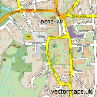
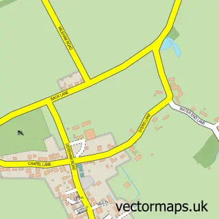
This Beetley street map is a detailed vector street map covering a 750m x 750m area. Select a larger area to create and download your own vector street map of Beetley.
The 750-metre map sample for Beetley covers 356 mapped buildings and approximately 11.0 km of road detail, of which 19 named roads are named. The immediate area includes 1 school and 2 MOT stations within 2 miles. The wider area around Beetley features 1 tourism point of interest. To create a larger or custom map of Beetley, the map builder lets you define your own coverage area and download editable SVG, PDF and PNG files.
Create a larger editable map of Beetley
Choose any area you need and generate a high-quality vector map instantly. Perfect for print, planning, design, business and personal use.

This Beetley street map in Norfolk is available as downloadable SVG, PDF and PNG map files, or as a printed map for planning, business, display, education, local information and design work. You can also create a larger custom map area using the map selector.
What this Beetley map sample shows
Beetley lies within Beetley Cp parish, part of Lincoln ward in the Breckland District local authority area. The postcode geography for this area includes the NR postcode area, the NR20 postcode district and the NR20 4 postcode sector. Residents fall under the Nhs Norfolk And Waveney Integrated Care Board for NHS services.
Local features near Beetley
Within 2 milesAmenities and services in and around Beetley.
Administrative and postcode information for Beetley
The local authority covering Beetley is Breckland District, within the county of Norfolk. The settlement lies within Lincoln ward and Beetley Cp civil parish. The NR20 postcode district and NR20 4 postcode sector serve the immediate area. NHS provision in the area is delivered through The Queen Elizabeth Hospital, King's Lynn, Nhs Foundation Trust.
Nearby street map samples around Beetley

More street maps in Norfolk
750 metre map area coverage
Boundary, postcode and point of interest information for the 750m x 750m rectangle centred on this sample map.
Boundaries containing map centre
Constituency: Mid Norfolk Co Const
County: Norfolk County
District: Breckland District
Icb: NHS Norfolk and Waveney ICB
Parish: Beetley CP
Police Force: norfolk
Postcode District: NR20
Postcode Sector: NR20 4
Ward: Lincoln Ward
Nearby boundaries intersecting sample
Parish: Gressenhall CP, Hoe and Worthing CP
Postcode coverage
POI category counts
Elementary School: 3
Building Supply Store: 2
Electrician: 2
Professional Services: 2
Active Life: 1
Art Museum: 1
Ceiling And Roofing Repair And Service: 1
Driving School: 1
Education: 1
Financial Service: 1
Sample points of interest
- Beetley Village Hall And Playing Field
- Gressenhall Farm And Workhouse
- Norfolk Thermal Solutions
- Paul Walters Plumbing & Heating
- G.B Cleaning Services
- Lee Bradshaw
- St Mary's Community Primary School
- Electrical Resolve Services
- Ian Cottingham Electrical
- St Mary's Community Primary School
- St. Mary's Community Primary School Beetley
- Zeocelz.shop
Create a larger editable map of Beetley
This sample shows only a 750 metre area. To create a larger map of Beetley, use our map builder to choose your own coverage area, add titles and download editable SVG, PDF and PNG files.
Create a custom map of Beetley