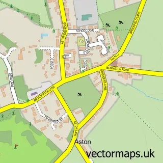
This Benington street map is a detailed vector street map covering a 750m x 750m area. Select a larger area to create and download your own vector street map of Benington.
The 750-metre map sample for Benington covers 137 mapped buildings and approximately 7.1 km of road detail, of which 6 named roads are named. The immediate area includes 1 school and 1 MOT station within 2 miles. The wider area around Benington features 1 tourism point of interest. To create a larger or custom map of Benington, the map builder lets you define your own coverage area and download editable SVG, PDF and PNG files.
Create a larger editable map of Benington
Choose any area you need and generate a high-quality vector map instantly. Perfect for print, planning, design, business and personal use.

This Benington street map in Hertfordshire is available as downloadable SVG, PDF and PNG map files, or as a printed map for planning, business, display, education, local information and design work. You can also create a larger custom map area using the map selector.
What this Benington map sample shows
Benington lies within Benington Cp parish, part of Walkern ward in the East Hertfordshire District local authority area. The postcode geography for this area includes the SG postcode area, the SG2 postcode district and the SG2 7 postcode sector. Residents fall under the Nhs Hertfordshire And West Essex Integrated Care Board for NHS services.
Local features near Benington
Within 2 milesAmenities and services in and around Benington.
Administrative and postcode information for Benington
The local authority covering Benington is East Hertfordshire District, within the county of Hertfordshire. The settlement lies within Walkern ward and Benington Cp civil parish. The SG2 postcode district and SG2 7 postcode sector serve the immediate area. NHS provision in the area is delivered through East And North Hertfordshire Nhs Trust.
Nearby street map samples around Benington


More street maps in Hertfordshire
750 metre map area coverage
Boundary, postcode and point of interest information for the 750m x 750m rectangle centred on this sample map.
Boundaries containing map centre
Constituency: North East Hertfordshire Co Const
County: Hertfordshire County
District: East Hertfordshire District
Icb: NHS Central East ICB
Parish: Benington CP
Police Force: hertfordshire
Postcode District: SG2
Postcode Sector: SG2 7
Ward: Aston, Datchworth & Walkern Ward
Nearby boundaries intersecting sample
No additional intersecting boundaries found.
Postcode coverage
POI category counts
Advertising Agency: 2
Anglican Church: 1
Automotive Repair: 1
Building Supply Store: 1
Business Management Services: 1
Car Dealer: 1
Church Cathedral: 1
Gardener: 1
Gift Shop: 1
Landmark And Historical Building: 1
Sample points of interest
- GEL Original
- Tyger Media
- St Peter, Benington
- Benington 4x4 Centre
- Marshmoor Bricks
- Whitehot Creative
- M R Sportscars
- St Peter's Church
- James Smith Gardens
- Red Elephant Promotions
- Benington Lordship Gardens
- Amagence
Create a larger editable map of Benington
This sample shows only a 750 metre area. To create a larger map of Benington, use our map builder to choose your own coverage area, add titles and download editable SVG, PDF and PNG files.
Create a custom map of Benington