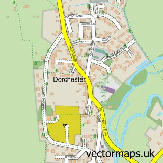
This Berinsfield street map is a detailed vector street map covering a 750m x 750m area. Select a larger area to create and download your own vector street map of Berinsfield.
The 750-metre map sample for Berinsfield covers 360 mapped buildings and approximately 16.0 km of road detail, of which 22 named roads are named. The immediate area includes 1 school, 1 GP surgery, with 2 within 2 miles, 1 pub and 3 MOT stations within 2 miles. The wider area around Berinsfield features 1 tourism point of interest and 3 food and drink venues. To create a larger or custom map of Berinsfield, the map builder lets you define your own coverage area and download editable SVG, PDF and PNG files.
Create a larger editable map of Berinsfield
Choose any area you need and generate a high-quality vector map instantly. Perfect for print, planning, design, business and personal use.

This Berinsfield street map in Oxfordshire is available as downloadable SVG, PDF and PNG map files, or as a printed map for planning, business, display, education, local information and design work. You can also create a larger custom map area using the map selector.
What this Berinsfield map sample shows
Berinsfield lies within Berinsfield Cp parish, part of Berinsfield ward in the South Oxfordshire District local authority area. The postcode geography for this area includes the OX postcode area, the OX10 postcode district and the OX10 7 postcode sector. Residents fall under the Nhs Buckinghamshire, Oxfordshire And Berkshire West Integrated Care Board for NHS services.
Local features near Berinsfield
Within 2 milesAmenities and services in and around Berinsfield.
Administrative and postcode information for Berinsfield
Berinsfield lies within Berinsfield Cp parish, part of Berinsfield ward in the South Oxfordshire District local authority area. The postcode geography for this area includes the OX postcode area, the OX10 postcode district and the OX10 7 postcode sector. Residents fall under the Nhs Buckinghamshire, Oxfordshire And Berkshire West Integrated Care Board for NHS services.
Nearby street map samples around Berinsfield


More street maps in Oxfordshire
750 metre map area coverage
Boundary, postcode and point of interest information for the 750m x 750m rectangle centred on this sample map.
Boundaries containing map centre
Constituency: Henley and Thame Co Const
County: Oxfordshire County
District: South Oxfordshire District
Icb: NHS Thames Valley ICB
Parish: Berinsfield CP
Police Force: thames valley
Postcode District: OX10
Postcode Sector: OX10 7
Ward: Berinsfield Ward
Nearby boundaries intersecting sample
No additional intersecting boundaries found.
Postcode coverage
POI category counts
Convenience Store: 4
Sports Club And League: 3
Elementary School: 2
Library: 2
Shipping Center: 2
Youth Organizations: 2
Anglican Church: 1
Atms: 1
Auto Electrical Repair: 1
Auto Manufacturers And Distributors: 1
Sample points of interest
- St Mary & St Berin
- Midcounties Co-Op Berinsfield
- Milner & Son Ltd.
- EiroMotors
- Berinsfield Information & Volunteer Centre
- Abbey Sports Centre
- Berinsfield Community Business
- Dorchester House Business Centre
- Communication Support Ltd.
- H Cafe
- Solidart
- Regency Exterior Cleaning
Create a larger editable map of Berinsfield
This sample shows only a 750 metre area. To create a larger map of Berinsfield, use our map builder to choose your own coverage area, add titles and download editable SVG, PDF and PNG files.
Create a custom map of Berinsfield