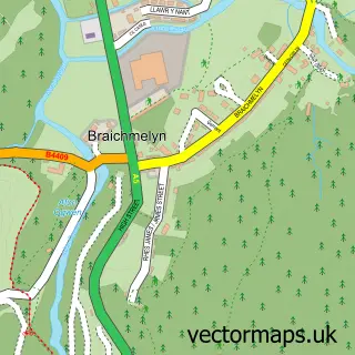
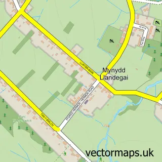
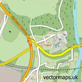
This Bethesda street map is a detailed vector street map covering a 750m x 750m area. Select a larger area to create and download your own vector street map of Bethesda.
The 750-metre map sample for Bethesda covers 282 mapped buildings and approximately 15.3 km of road detail, of which 33 named roads are named. The immediate area includes 2 schools, 3 pubs and 2 MOT stations, with 4 within 2 miles. The wider area around Bethesda features 4 tourism points of interest, 7 food and drink venues and 1 hotel. To create a larger or custom map of Bethesda, the map builder lets you define your own coverage area and download editable SVG, PDF and PNG files.
Create a larger editable map of Bethesda
Choose any area you need and generate a high-quality vector map instantly. Perfect for print, planning, design, business and personal use.

This Bethesda street map in Gwynedd is available as downloadable SVG, PDF and PNG map files, or as a printed map for planning, business, display, education, local information and design work. You can also create a larger custom map area using the map selector.
What this Bethesda map sample shows
Bethesda lies within Bethesda Community parish, part of Gerlan ward in the Gwynedd - Gwynedd local authority area. The postcode geography for this area includes the LL postcode area, the LL57 postcode district and the LL57 3 postcode sector. Residents fall under the Betsi Cadwaladr University Health Board for NHS services.
Local features near Bethesda
Within 2 milesAmenities and services in and around Bethesda.
Administrative and postcode information for Bethesda
The local authority covering Bethesda is Gwynedd - Gwynedd, within the county of Gwynedd. The settlement lies within Gerlan ward and Bethesda Community civil parish. The LL57 postcode district and LL57 3 postcode sector serve the immediate area. NHS provision in the area is delivered through Betsi Cadwaladr University Health Board.
Nearby street map samples around Bethesda

More street maps in Gwynedd
750 metre map area coverage
Boundary, postcode and point of interest information for the 750m x 750m rectangle centred on this sample map.
Boundaries containing map centre
Constituency: Bangor Aberconwy Co Const
District: Gwynedd - Gwynedd
Icb: Betsi Cadwaladr University
Parish: Bethesda Community
Police Force: north wales
Postcode District: LL57
Postcode Sector: LL57 3
Nearby boundaries intersecting sample
Parish: Llandygai Community
Postcode Sector: LL57 4
Postcode coverage
POI category counts
Convenience Store: 6
Indian Restaurant: 4
Cafe: 3
Charity Organization: 3
Fish And Chips Restaurant: 3
Park: 3
Pub: 3
Automotive Repair: 2
Bar: 2
Barber: 2
Sample points of interest
- Family Planning Association
- Crochendy Bethesda Pottery
- Siop Ogwen
- Veterans Shed Gwynedd
- Neuadd Ogwen
- Ogwen Mobile Valeting
- Central Garage
- Pesda Cars
- Central Garage
- Ffrydlas Garage
- George Inn
- The Bull Inn
Create a larger editable map of Bethesda
This sample shows only a 750 metre area. To create a larger map of Bethesda, use our map builder to choose your own coverage area, add titles and download editable SVG, PDF and PNG files.
Create a custom map of Bethesda