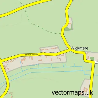
This Blickling street map is a detailed vector street map covering a 750m x 750m area. Select a larger area to create and download your own vector street map of Blickling.
The 750-metre map sample for Blickling covers 27 mapped buildings and approximately 5.8 km of road detail, of which 1 named road are named. The immediate area includes 1 GP surgery within 2 miles, 2 pubs and 3 MOT stations within 2 miles. The wider area around Blickling features 3 tourism points of interest and 3 food and drink venues. To create a larger or custom map of Blickling, the map builder lets you define your own coverage area and download editable SVG, PDF and PNG files.
Create a larger editable map of Blickling
Choose any area you need and generate a high-quality vector map instantly. Perfect for print, planning, design, business and personal use.

This Blickling street map in Norfolk is available as downloadable SVG, PDF and PNG map files, or as a printed map for planning, business, display, education, local information and design work. You can also create a larger custom map area using the map selector.
What this Blickling map sample shows
Blickling lies within Blickling Cp parish, part of Aylsham ward in the Broadland District local authority area. The postcode geography for this area includes the NR postcode area, the NR11 postcode district and the NR11 6 postcode sector. Residents fall under the Nhs Norfolk And Waveney Integrated Care Board for NHS services.
Local features near Blickling
Within 2 milesAmenities and services in and around Blickling.
Administrative and postcode information for Blickling
Blickling lies within Blickling Cp parish, part of Aylsham ward in the Broadland District local authority area. The postcode geography for this area includes the NR postcode area, the NR11 postcode district and the NR11 6 postcode sector. Residents fall under the Nhs Norfolk And Waveney Integrated Care Board for NHS services.
Nearby street map samples around Blickling

More street maps in Norfolk
750 metre map area coverage
Boundary, postcode and point of interest information for the 750m x 750m rectangle centred on this sample map.
Boundaries containing map centre
Constituency: Broadland and Fakenham Co Const
County: Norfolk County
District: Broadland District
Icb: NHS Norfolk and Waveney ICB
Parish: Blickling CP
Police Force: norfolk
Postcode District: NR11
Postcode Sector: NR11 6
Ward: Aylsham Ward
Nearby boundaries intersecting sample
No additional intersecting boundaries found.
Postcode coverage
POI category counts
Landmark And Historical Building: 2
Pub: 2
Anglican Church: 1
Cafe: 1
Park: 1
Sports And Recreation Venue: 1
Sample points of interest
- Blickling Parish Church (St Andrew's)
- Muddy Boots Café
- Blickling Estate NT
- National Trust
- Blickling Hall
- The Buckinghamshire Arms
- The Bucks Arms
- Blickling Junior Parkrun
Create a larger editable map of Blickling
This sample shows only a 750 metre area. To create a larger map of Blickling, use our map builder to choose your own coverage area, add titles and download editable SVG, PDF and PNG files.
Create a custom map of Blickling